Monthly Archives: April 2021

372 Great Lakes Drone Company

An interview with Great Lakes Drone Company, producers of drone light shows. Also, first responders and augmented reality controlled UAVs, drones that locate trash, Wing drone delivery expansion plans, QR codes in the nighttime sky, and a drone that launches a drone.

Great Lakes Drone Company
Great Lakes Drone Company drone show.

Guests

We talk with Ashley Munson and Lindsay Nitz from Great Lakes Drone Company about producing drone light shows. Recorded at the 2021 Sun ‘n Fun Aerospace Expo on April 17, 2021.

UAV News

New Headsets Let Police Control Drone Swarms ‘Hands Free’

Researchers want to support firefighters in Montréal during fire-related emergencies. Their solution is a swarm of drones and an augmented reality headset. They designed an AR interface using the Magic Leap 1 headset that can manage the UAVs in stressful situations.

Drones for the Environment: Battling Trash in San Francisco Estuaries

California researchers are using imagery from unmodified DJI Mavic 2 Pro drones and AI to find plastics and trash along the banks of creeks and streams. The idea is to collect the rubbish before it washes into the bay or the ocean.

Alphabet unit Wing seeks FAA OK to help expand U.S. drone operations

Wing wants to grow its drone delivery service beyond the Christiansburg, Virginia residents that are now supported. Wing is petitioning the FAA to consolidate remote pilot operations from local facilities “to regional operations facilities that are capable of safely controlling a larger number of aircraft simultaneously.” They also want to use a derivative version of the drones and change the operator line check requirement to every 12 months instead of every three months. The FAA says they’ll accept public comments on the petition before making a decision.

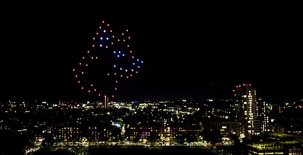
The future of advertising is here, and it’s a giant QR code formed by drones flying over Shanghai

Chinese video sharing and streaming site Bilibili created a large nighttime drone display that included a QR code in the sky using 1,500 drones. This was part of a light show celebrating a video game anniversary. Bilibili posted a video with the entire performance:

Video: Princess Connect! Re:Dive drone show

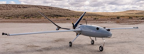
Valkyrie drone launches even smaller drone from inside payload bay

A Kratos XQ-58A Valkyrie experimental “attritable” drone successfully released an ALTIUS-600 autonomous drone. The ALTIUS-600 is a small tube-launched drone made by Area-I and it was released from the Valkyrie internal weapons bay. The XQ-58A Valkyrie is designed and built by Kratos for the USAF Low-Cost Attritable Strike Demonstrator program. The ALTIUS-600 is part of the ALTIUS family of autonomous UAS that can be launched from the air, sea, and ground from systems like the Common Launch Tube (CLT), Pneumatically Integrated Launch System (PILS), and other launch systems.

371 LiDAR Mapping with UAVs

LiDAR Specialist Lukas Fraser

Lukas Fraser is a LiDAR Specialist working in the Geospatial Group at NV5. He creates engineering-grade 3D mapping deliverables from UAV LiDAR and imagery, and specializes in topographic and topo-bathymetric LiDAR data collection, processing, analysis, and product development. Lukas turns raw datasets into useful information such as AutoCAD drawings and surfaces, GIS databases, or online interactive web maps. He’s a graduate of the Geodesy and Geomatics Engineering program at the University of New Brunswick.

Lukas describes how UAVs with the sensors now available are changing data collection and making applications possible that would have been difficult previously.

Lukas explains how LiDAR works and some of the key applications. He talks about the process to collect LiDAR and image data with UAVs that meet accuracy standards, how that data is analyzed, and then how products are created that the client can use to get value from the project. Imagery from a UAV can result in RGB, thermal, multispectral, or hyperspectral products. LiDAR data can be used for topographic and topo-bathymetric products.

Using UAVs for applications like these is an emerging capability, and just one more example of how drones are changing commercial activity.

370 Detect and Avoid

Robust detect and avoid capability is essential for integrating BVLOS flight into the National Airspace System. We talk with the CEO of a company on the forefront of this technology.

Guest

Jon Damush is the CEO of Iris Automation, which provides onboard detect and avoid technology for Beyond Visual Line of Sight drone flight.

Jon Damush, CEO, Iris Automation

Iris is primarily a computer vision and machine learning software company that is focused on helping unpiloted systems detect other airplanes. The company’s Casea product is a platform-agnostic 360-degree radial computer vision detect and avoid system for UAS.

Casea hardware includes an array of cameras and a central compute unit. The software employs machine learning techniques to determine the distance to a target. The targets detected by the cameras are classified and their size indicates their distance.

Jon explains the importance of detect and avoid for unpiloted aircraft and how the Casea system operates. He also discusses regulator desire for detection method consistency, but he argues that the future might lie with a multi-modal system using optical, auditory, and radar detection.

Casia 360 on Saxon M14.

The Regulatory Resource Center (RRC) captures Iris learnings and provides a place to start for those considering building a drone business, or those who have a drone business and want to go beyond visual line of sight.

Iris is participating in a Canadian Pathfinder program with partners  Foremost UAS Test Range in Alberta and UAS Center of Excellence (CED) in Alma, Quebec. The program includes flight training, assistance gaining BVLOS approvals, a BVLOS safety system, engineering and regulatory support, and test center access. It is open to any organizations interested in operating BVLOS services inside Canada. See: Iris Automation Launches Canada Pathfinder Program to Advance Commercial Drone Operations Readiness, Approvals.

Jon also explains how the World Economic Forum is working to promote the value drones can provide. See: WEF Aerospace and Drones.

Jon has over 30 years of aviation technology experience and executive leadership. He led new business ventures at Boeing NeXT, he was Chief Growth Officer at Boeing subsidiary Insitu, and he was a Boeing executive liaison and board observer to SkyGrid, a joint venture between Boeing and SparkCognition. Jon was the CEO of 2d3 Sensing, a leading provider of computer vision-based image processing software for aerial surveillance. He is also an FAA-certified commercial pilot with multi-engine and instrument ratings and he’s a certified flight instructor.

369 A Rescue Drone That Talks

A rescue drone with 2-way voice radio capability, using trained bees and drones to find landmines, telehealth drones that visit your home, quadcopters that work together to deliver large packages, and delivering lifejackets for water rescues.

UAV News

Two Way Radio for Drones Means Rescuers Can Hear a Cry for Help

A rescue drone can be used to find you, but what if you could talk back to the rescue drone? Dotterel Technologies has a 2-way radio solution that could aid in search and rescue. This would allow a conversation with the person being searched for, or even the ability to listen for a cry for help to locate someone. A highly directional microphone array and real-time processor make this possible.

Video: Dotterel Aerial Audio – World’s First UAV with Two-Way Communication

How bees and drones team up to find landmines

Old landmines are a serious problem in some areas of the world. According to Landmine Monitor, 6,897 people were killed or injured by mines and explosive remnants of war in 2018. There are an estimated 80,000 landmines in Bosnia and Herzegovina and about 30,000 in Croatia.

The mines are difficult to find, however, bees can be trained to detect the scent of the explosives with their antennae. Now a team from Bosnia and Herzegovina and Croatia have found a way to use drones to capture video of the bees that can be analyzed to indicate where landmines may be hidden in the ground.

New UC telehealth drone makes house calls

Telehealth has grown tremendously during the pandemic. But not everybody has the Internet. Now four Inventors from three colleges at the University of Cincinnati have collaborated to develop a semi-autonomous prototype drone that can be sent to people’s homes. The small quadcopters use navigational algorithms developed by UC engineers to maneuver inside a home.

Control System Helps Several Drones Team Up to Deliver Heavy Packages

A Georgia Tech Indoor Flight Lab is using multiple drones to lift a heavy package. A control algorithm directs a team of small drones. They measure thrust and altitude to estimate the weight of the package and could even be sent to your location to pick up a large package. The demonstration used four drones, but the control algorithm isn’t limited to that number. This solution might be better than a fleet of drones of different sizes and lift capacity. In many ways, controlling a group of connected drones is more difficult than controlling a swarm of robots that fly independently.

Video: Small drones work together to lift and deliver packages

Sheriff drones can now deliver lifejackets during water rescues

The San Mateo County Sheriff’s office announced they can deliver lifejackets to swimmers in need. A small quadcopter carries the lifejacket on a short tether and a button on the controller lets the officer drop the life jacket. The drone remains in the air some distance above the swimmer. This is part of their Water Safety Campaign. Video on Instagram.

UAV Video of the Week

Drone captures images of a reindeer ‘cyclone’

The video shows reindeer circling in a protective group with the fawns in the center. For more see Reindeer Cyclones Are Real, and You Definitely Don’t Want to Get Caught in One.

Video: This drone footage shows a reindeer cyclone in all its glory