Monthly Archives: November 2015

UAV122 Realtime Flight Restriction Data Coming to UAVs

DJI geofencing systemDJI and 3D Robotics bring real-time airspace restrictions to UAV software, a UAV flagship store is planned to open, ArcadiaSky opens a marketplace for commercial UAV operators, FAA gives a UAV registration warning, and another municipality regulates drone flights.

News

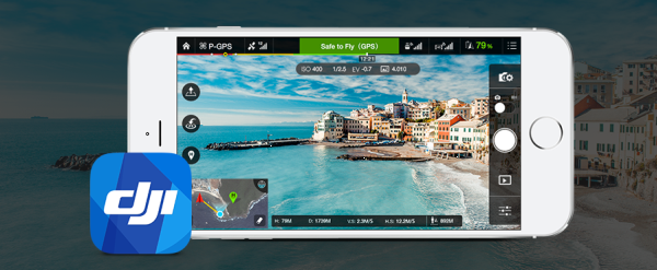
DJI Introduces New GeoFencing System For Its Drones

DJI plans to introduce a dynamic geofencing system that continuously provides updated airspace information to the operator. Data comes from Geospatial Environment Online (GEO). Drone operators will see temporary flight restrictions (TFRs) in real time, including forest fires, major stadium events, VIP travel, and restrictions around prisons, power plants, and other restricted areas such as national parks.

However, operators with verified DJI accounts could temporarily unlock or self-authorize flights in some of those locations, but not in sensitive national-security locations. This to accommodate the authorized applications and provide accountability if the flight is later under investigation.

DJI intends to start this in December, first in North America and Europe via a DJI Go app update, and also a drone firmware update.

GEO is powered by geospatial data from Santa Monica, California-based AirMap, which calls itself “the leading provider of airspace information and services for drones. AirMap’s real-time services are available to manufacturers through an API and through an SDK for application developers.”

Just as we were recording this episode, a video was posted from Drone World Expo titled DJI Technology Policy Announcement by Brendan Schulman, VP of Policy & Legal Affairs.

3DR Collaborates with AirMap to Integrate Flight Safety Zone Software into the Solo App

3D Robotics will also integrate AirMap’s safety information into its Solo smart drone app. CEO and co-founder Chris Anderson says, “…we want to make flying as safe as it is easy. Supplementing the Solo app with AirMap’s robust and reliable real-time airspace information allows us to increase education with a seamless and enjoyable drone experience.”

From the 3DR press release: “If Solo users open their Solo app in a restricted area, they’ll see a warning. Users can then tap the warning to bring up a map that displays any airspace information in the area. This airspace information includes real-time Temporary Flight Restrictions that may be established in the areas around wildfires, major sporting events and other sensitive places. The Solo app will contain basic airspace information: federal guidelines (e.g., five miles from an airport); national parks; airbases, etc.”

The World’s Biggest Commercial Drone Maker is Opening a Flagship Store

In December, DJI plans to open an 8,600 square foot flagship store in Shenzhen, China. A DJI spokesman said, “We want more people to see and touch our products.”

Start-up ArcadiaSky creates marketplace for commercial UAV hire

Australian company ArcadiaSky wants to make it easier to find licenced commercial UAV operators. After two months, they have 180 drone operators in 74 locations in Australia, the United Kingdom, and the United States. They’ve received over 1,300 requests for quotes.

ArcadiaSky describes a free, three-step process:

  1. Define your requirements on a request for quote
  2. Choose your pilot based on your requirements
  3. You are put in contact with the drone operator

FAA: Think Twice about “Drone Registration” Firms

The FAA has issued a statement saying UAV owners should wait for the registration process to be announced before they work with any company that offers to help you with registration.

At least one company is offering this kind of service.

The FAA wants “a streamlined unmanned aircraft registration process that will be simple and easy to complete… The Task Force …is working on recommendations for a system that is similar to registering any newly purchased product with its manufacturer…”

Chicago City Council Approves Ban On Drones

The Chicago City Council approved an ordinance regulating drone use and requiring that drones cannot fly above 400 feet, must be line-of-sight, and cannot fly within five miles of O’Hare and Midway Airports. Also, no flying of drones over schools, churches, hospitals, police stations, and any private property without consent.

Video of the Week

DroneFest, the International Drone Film Festival

This international film and photography competition culminates in a one-night festival dedicated to everything drones. It’s part of the SkyTech 2016 Drone Expo on the 27th January 2016. Submissions are accepted until December 13, 2015.


UAV121 UAS Registration Update

The Facebook Aquila 1

Aquila 1 courtesy Facebook

“Polivation” policy briefing, UAS registration update, multicopters crash in Seattle, charges of misrepresenting UAS to the US Government, Google and Facebook want to be ISPs, and the tower industry looks ahead to UAS.

Implementing Polivation to Achieve Autonomy: A Path Forward

Hogan Lovells UAS GroupDavid tells us about the policy briefing he attended where panelists addressed issues of “polivation,” the intersection of policy making and innovation. Held at the City Club of Washington (D.C.) on November 12, 2015, the event was moderated by Gloria Story Dittus, chairman of Story Partners, a leading strategic communications firm headquartered in Washington, D.C. The panelists were:

  • John Verdi [PDF], Director of Privacy Initiatives, National Telecommunications and Information Administration, U.S.Department of Commerce
  • Lisa Ellman, Partner, Hogan Lovells and co-chair of the firm’s Unmanned Aircraft Systems (UAS) Group.
  • Gretchen West, Senior Advisor, Hogan Lovells, focusing on innovation and technology and a member of the firm’s Unmanned Aircraft Systems (UAS) Group in Silicon Valley.
  • Travis Mason, Public Policy and Government Relations, Google[x].

UAS Registration Task Force Update

Day 2 Update

“The discussion focused on developing and recommending a registration process, how to prove the UAS is registered and how to mark a UAS. The discussion about the registration process focused on the type of system that should be built and the type of information that should be collected.”

Day 3 Update

“The group focused on reaching a consensus on a recommended process for registration. The discussions included how an operator might prove a UAS is registered, how the aircraft would be marked, and how to use the registration process to encourage or require UAS operators to become educated on basic safety rules. The group also continues to gather data and analyze which types of UAS would need to be registered and which would not. The Task Force will now finalize its recommendations for delivery to the FAA Administrator by November 20.”

News

Drone hits Seattle’s huge Ferris wheel; SPD investigating

A drone struck the Seattle Great Wheel, a 175-foot tall ferris wheel. There were no reports of injury or damage, but police confiscated the drone.

Man charged for Seattle drone crash that knocked woman out

Recall that in June, a drone crashed into a building and struck a woman in the head. The operator has been charged with reckless endangerment, a misdemeanor charge with a maximum penalty of 364 days in jail and a $5,000 fine. The Seattle City Attorney’s Office said the charge is not because it was a drone, but because of the actions taken with the drone.

Met wants a drone register to manage the UAV menace

Drones were a topic at the Web Summit show in Dublin. Chief inspector Nick Aldworth of the Metropolitan Police and Ralph James of the Irish Aviation Authority (IAA) agreed that Ireland needs a drone registry for security and privacy protection reasons.

Drone Company Misled Military into Buying UAVs that Were Basically Toys: Lawsuit

A motion has been filed in civil court alleging that Florida company Prioria Robotics misrepresented its Maveric UAS, a bird-like, portable, fixed-wing UAV that can be launched by a single-person. According to Prioria, the Maveric is capable of autonomous operation, weighs 2.6 pounds, with a 45-60 minute endurance. The Prioria website describes military, public safety, and commercial applications.

Prioria has won contracts with the Army, the Navy, the Air Force, NASA, and other federal agencies. The Defense Logistics Agency paid $240,000 per Maveric system. UAS vendor and Maveric retailer Condor Aerial says the specs are inaccurate and Prioria is charging military-grade prices for what is essentially a hobby drone.

Facebook’s laser drones v Google’s net-beaming balloons

Both Facebook and Google want to provide Internet service to the 57% of the world’s population that isn’t online. Facebook has built the Aquila 1 in England and sent it to an undisclosed location for testing. It’s propeller-driven by four solar-powered motors and made of foam covered with carbon fiber. Google has a drone-based project, but isn’t providing a lot of details. They also have the balloon-based Project Loon.

NATE Unmanned Aerial Systems Committee looks to prevent tragedies

The National Association of Tower Erectors established an Unmanned Aerial Systems Committee to monitor trends, regulatory concerns, and to make recommendations to NATE about best practices for drone use in the tower industry.

In the following video, host Joey Jackson of Cell Tower News talks with founding members of the Unmanned Aerial Systems Committee, Phil Larsen, President of Telecommunications at HAZON Solutions and Jim Goldwater, Senior Vice President at Bob Lawrence & Associates, Inc.

Video of the Week

Watch World’s First Jet-Powered, 3D Printed UAV Top 150 Mph!

Aurora Flight Sciences teamed up with additive manufacturing company Stratasys to create a jet-powered, 3D printed aircraft.

More at: World’s first jet-powered, 3D-printed UAV debuts at Dubai Airshow

UAV120 Drones that Avoid Obstacles

3-D environment mapSystems that allow drones to avoid obstacles, impediments to package delivery by UAV, the UAS registration task force kicks off and gets some help, and interviews and presentations from the UAS Industry Days conference.

News

A Drone with a Sense of Direction

The Swiss Federal Institute of Technology in Zurich has demonstrated a multirotor drone that creates 3-D maps of its environment. The first flight must be manual so the drone can build the map. After that, the drone can fly autonomously in that environment. The system uses stereo camera and sensors, and all data collection and processing is onboard the UAV.

New obstacle avoidance tech lets this drone zip through a thicket at top speed

MIT’s Computer Science and Artificial Intelligence Lab (CSAIL) has developed an autonomous drone with a detection system that can navigate through obstacles. The software looks ahead 10 meters, detects hazards in the flight path, and adjusts the UAVs trajectory in real time.

Here’s Why Drone Delivery Won’t Be Reality Any Time Soon

Package delivery by drone continues to get a lot of attention. Amazon, Google, and even retail giant Walmart are looking at systems that can move items by UAV. But there are many obstacles to be overcome. David Vanderhoof explains some of the challenges in this Time article.

Statement: UAS Registration Task Force Day One

FAA Administrator Michael Huerta kicked off the UAS Registration Task Force on November 3, 2015. “The FAA briefed participants on the current statutory requirements and international obligations for aircraft registration before the group began initial discussions on a streamlined registration process and minimum requirements for UAS that need to be registered.”

LoBiondo and Larsen Outline Priorities for Proposed FAA Unmanned Aircraft Registry

House Aviation Subcommittee Chairman Frank LoBiondo (NJ-02) and Ranking Member Rick Larsen (WA-02) sent a letter to FAA Administrator Michael Huerta outlining their top priorities in establishing a national registry for UAS. The letter outlines four priorities that they want the task force to consider:

  1. Streamlined Process
  2. FAA Access to Data
  3. Education and Training
  4. Incentives for Consumers to Register

UAS Industry Days recordings

We have a webpage with the interviews we conducted with speakers, attendees, and exhibitors at the NUAIR Alliance and Empire State Chapter of AUVSI UAS Industry Days conference held September 22-23, 2015. We also have some of the presentations delivered at the conference.

The webpage is http://theUAVdigest.com/UASIndustryDays2015 and you can play the recordings right from that page, or download them and listen later. You will also find a link to photos from the event.

Interviews include Aurora Flight Sciences, Mid-Atlantic Aviation Partnership, ULC Robotics, and Lockheed Martin Information Systems & Global Solutions. We have presentations from Lisa Ellman of Hogan Lovells, Mark Aitken who is the Federal Government Regulations manager with AUVSI, and Arland Whitfield, president of The Skyworks Project. Also included are recordings of the agriculture and public safety panels.

Video of the Week

Stupidest Drone Crash Ever (w/pumpkin) – I’m a moron

A DJI Phantom 2 visits a pumpkin farm that happens to have a pumpkin cannon. For more of this “sport” visit https://www.punkinchunkin.com/.