Tag Archives: PrecisionHawk

UAV098 HeliVideo to Provide Footage at U.S. Open

The HeliVideo fleet

HeliVideo to cover U.S. Open, commercial drone market share, China uses drone to catch cheaters, using TV signals to sense aircraft, a Google drone patent, and UAS full type certificates.

News

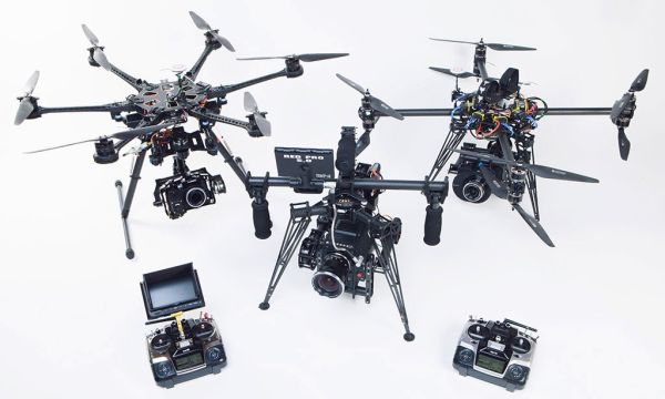
How FOX Sports will use drones at the U.S. Open, and why the FAA is watching

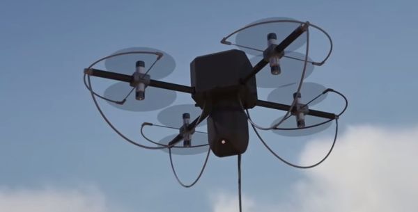
FOX Sports is using octocopters from Austin-based HeliVideo to cover the golf championship at Chambers Bay. HeliVideo says they provide “FAA approved cinematography for television and film.” The HeliVideo fleet includes a Small Sensor Hexacopter with a Panasonic Lumix GH3, a Full Frame Octocopter sporting a Canon 5D Mark 3, an EPIC 6k Dragon Octocopter, and an EPIC 6k Dragon Single blade helicopter.

For the golf tournament, HeliVideo is bringing a four-man team and more than $1 million in equipment — including the DJI Spreading Wings 1000 drone. HeliVideo received their exemption last September. An authorized, licensed pilot will fly the drones, while a visual observer will keep tabs on the devices at all times.

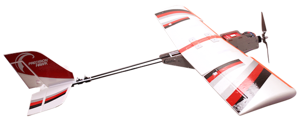
Forty eight percent of commercial drone platforms in the USA made by DJI

sUAS News reports that DJI has 48.4% of the “commercially licenced platforms” in service. AeroVironment follows with 12.1%, 3DR with 7.6%, and Precision Hawk with 3.9% This is from a total population of 380 platforms.

Authorizations Granted Via Section 333 Exemptions

This list from the FAA shows Petitioners, Grant Issue Date, Operation/Mission, and the Authorizations document.

China Uses a Drone to Curb Cheating on College Placement Exams

The National College Entrance Exams in China are critical to the future success of the 9.5 million students who take the 2-3 day test. This has led to cheating schemes where students send exam questions out to others, who then transmit answers back to the student.

Now Chinese education authorities are fighting back with a drone. It flies over testing centers and scans for signals being sent to devices brought in by students. The drone is reported to be about the size of a gas station pump and cost tens of thousands of dollars.

TV signals a possible alternative to radar

Air traffic control company NATS has been working with Thales and contract R&D company Roke Manor to see if television transmission signals could be used to detect and direct aircraft. In a trial conducted over London, more than 30 aircraft were tracked at altitudes of up to 10,000 feet.

Google Working On Fleet of Drone Ambulances To Save Your Life, Reveals a Newly Granted Patent

Google was granted United States Patent 9,051,043 titled “Providing emergency medical services using unmanned aerial vehicles.” It provides for a fleet of UAVs configured to: identify remote medical situations, determine the target location, select a UAV with the proper configuration, and deploy the UAV to the target location to provide medical support. Sounds a lot like the Amazon drone delivery patent.

FAA Working Eight UAS Full Type Certificates

A type certificate would allow a UAS manufacturer to fly the aircraft throughout U.S. airspace. Larger UASs like the Boeing Insitu ScanEagle and AeroVironment’s Puma fly under type certificates issued in the Restricted category. Experimental type certificates have been issued to other UASs which generally prohibit commercial uses. There are no type certificate requirements for UASs under 55 pounds.

Mentioned

Expert: Drones Causing Major Aviation Disasters Is ‘A Question Of When It’s Going To Happen, Not If’

David provides expert opinion to CBS DC.

UAV093 AUVSI Unmanned Systems 2015 Conference

The WATT tethered drone

News from the 2015 AUVSI Conference, including the Pathfinder Program where the FAA partners with industry to develop commercial UAS technology.

AUVSI Unmanned Systems 2015 Conference

The Association for Unmanned Vehicle Systems International (AUVSI) held its Unmanned Systems 2015 Conference May 4-7 in Atlanta, Georgia.

At the Conference, the FAA announced the “Pathfinder Program” which it called “a partnership with industry to explore the next steps in unmanned aircraft operations beyond the type of operations the agency proposed in the draft small unmanned aircraft systems rule it published in February.”

Speech – “UAS Pathfinder Program Announcement Press Conference”

Press Release – FAA-Industry Initiative Will Expand Small UAS Horizons

In his speech, FAA Administrator Michael Huerta said, “We’re partnering with three leading U.S. companies who have committed extensive resources to perform research that will help us determine if and how we can safely expand unmanned aircraft operations in the United States. These companies reached out to the FAA to work with us on exploring three key types of unmanned operations.”

The industry partners and three focus areas are:

  • Visual line-of-sight operations in urban areas. CNN will look at how UAS might be safely used for newsgathering in populated areas.
  • Extended visual line-of-sight operations in rural areas. This concept involves UAS flights outside the pilot’s direct vision. UAS manufacturer PrecisionHawk will explore how this might allow greater UAS use for crop monitoring in precision agriculture operations.
  • Beyond visual line-of-sight in rural/isolated areas. BNSF Railway will explore command-and-control challenges of using UAS to inspect rail system infrastructure.

Huerta said, “We anticipate receiving valuable data from each of these trials that could result in FAA-approved operations in the next few years. They will also give insight into how unmanned aircraft can be used to transform the way certain industries do business – whether that means making sure trains run on time, checking on the health of crops, or reporting on a natural disaster.”

On the NPRM, Huerta commented on the number of public comments received, noting that it will take time to address them and finalize the rule. The Pathfinder Program is designed to expand expand the use of unmanned aircraft in the meantime.

PrecisionHawk to work with FAA on UAV extended line-of-sight safety

PrecisionHawk will formulate a framework for fixed wing and multirotor UAVs for missions in agriculture, forestry, and other rural industries. PrecisionHawk will also test its LATAS (Low Altitude Tracking & Avoidance System) traffic management system.

AUVSI: New tethered UAV for CNN

CNN announced that it will become the launch customer for the Drone Aviation Corp WATT UAV.  This tethered drone that can take power from the tether and simultaneously transmit data back to the ground. The electric quadrotor is activated with a mobile tablet and can hover at up to 300 feet for 8 hours.

Tim Trott Interview with Jay Willmott

At the AUVSI Conference, Tim Trott from Southern Helicam caught up with Jay Willmott, Founder and President of unmanned technology consultancy Nexutech.

Vortex UAS

A conversation with Vince Donahue, the Founder and President of Vortex UAS. Vortex provides tailored solutions for businesses utilizing UAS, including pilot training, consulting, and other services. This is a condensed version of the full interview originally published in Episode 347 of the Airplane Geeks podcast.

Videos of the Week

Surf the world’s most extraordinary waves with drone videos

Shot by photographer Eric Sterman with a GoPro on a Phantom 2 during two days at the “Jaws” surf break on the North shore of Maui.

Good Morning, San Diego!

The scenes in this video were captured around sunrise over a period of four months. Shot using a GoPro HERO3 Black Edition camera mounted on a DJI Phantom 2 Quadcopter with Zenmuse H3-3D 3-axis gimbal.

UAV080 UAV Tracking and Avoidance

LATAS (Low Altitude Tracking and Avoidance System)

A new tracking and avoidance system, drones that assist firefighters, a Phantom firmware rollback, drone waiters that bring your meal, a personal No Fly Zone, shooting down those pesky drones, Qualcomm buys KMel Robotics, and California seeks to regulate drones below 400 feet.

News

PrecisionHawk Announces UAV Tracking and Avoidance System

PrecisionHawk released an automated traffic control system for UAVs said to aid with the integration of UAVs into the National Airspace (NAS). The “Low Altitude Tracking and Avoidance System” (LATAS) uses global cellular networks on speeds as low as 2G. to provide real-time flight planning, tracking and avoidance for UAVs.

LATAS is small (3x2x1in) and light and was developed to be plug and play or integrated into a UAV’s circuit during manufacturing.

Micro-flyer drone could help a robot to fight fires on ships

Last November, the US Office of Naval Research conducted a demonstration of its Shipboard Autonomous Firefighting Robot (SAFFiR) along with an autonomous quadcopter drone. The robot/drone combination is intended to assist firefighters aboard naval vessels. This is under the Office of Naval Research’s Damage Control Technologies for the 21st Century (DC-21) project. The quadcopter comes from Carnegie Mellon University’s Robotics Institute and Sensible Machines.

This Spherical Rescue Drone Is Straight Out of Star Wars

Flyability has introduced what it calls “the world’s first collision-proof drone.” The “Gimball” search and rescue drone is spherical and bounces off obstacles to keep flying. It has a coaxial twin rotor design inside a rotating protective carbon fiber frame. In Crash-proof UAV takes out US$1 million Drones For Good Competition we learn that the Flyability Gimball took first place in the Drones For Good contest.

Unexpected issues force drone maker DJI to roll back ‘White House’ update

DJI has rolled back the geofencing firmware update for the Phantom — also known as the “White House patch” — because there have been reports of “unanticipated flight behavior.”

Drone waiters to serve patrons in Singapore restaurants

Infinium Robotics specializes “in providing autonomous UAV solutions for commercial applications.” That includes food delivery by drone in some Singapore restaurants. The rotors are completely enclosed to avoid injury and the UAVs utilize sense and avoid technology.

Singapore currently has a shortage of workers in the food industry so this is covering a real need.

NoFlyZone Lets You Establish A No-Fly Zone Over Your Property

NoFlyZone creates a GeoFence around your home after you register your property. Currently,  the service works with UAS manufacturers DroneDeploy, YUNEEC, HEXO+, PixiePath, RCFlyMaps. EHANG, and Horizon Hobby.

Oklahoma bill would allow property owners to shoot down drones without civil liability

The Oklahoma State Senate Judiciary Committee passed Senate Bill 492, giving property owners the right to shoot down drones without fear of civil liability. Backers say that drones are increasingly being used by cattle thieves. This bill would protect property owners should they be sued by thieves over a shot down drone.

Qualcomm Buys Aerial Drone Startup with Advanced Control Technology

Chipmaker Qualcomm has acquired startup KMel Robotics, which specializes in multi-rotor drones. Qualcomm isn’t providing any details other than to point to the KMel Robotics website: “We are extremely excited to become part of the Qualcomm team and look forward to bringing aerial robotics to the next level together.”

KMel Robotics has produced videos demonstrating impressive flight coordination:

California’s No Drone Zones

California bill SB142 bans trespassing by drones flying below 400 feet.

Mentioned

UOIT Controls The Weather At Its Drone Testing Centre

The University of Ontario Institute of Technology has launched the ACE Centre for UAV Research.

Want to fly your drone and make a quick buck? The FAA has 33 rules for you.

UAV057 PrecisionHawk

PrecisionHawk Lancaster PlatformGuest Dr. Ernest Earon is President and Co-founder of PrecisionHawk. Their Lancaster Platform is designed around the goals of ease of use and autonomous collection of high resolution aerial data.

Much of the focus is on agricultural applications, but their platform, and data collection and analysis methodology is applicable to a variety of industries.

The NUAIR Alliance, one of the six FAA UAS Test Sites, has a COA for the PrecisionHawk and we talk with Dr. Earon about that program. Also, we discuss the UAV industry in general, operating in an environment of regulatory uncertainty, and prospects for the future.

The PrecisionHawk UAV & Data Software video presents an overview of the PrecisionHawk company and the capabilities of the Lancaster Platform.


Dr.EaronDr. Earon earned his doctorate from the University of Toronto Institute for Aerospace Studies in 2004, and has over 10 years experience in the field of unmanned aerial vehicles and intelligent, autonomous vehicle control. He has led development teams for the Canadian Space Agency, Quanser, and Defense R&D Canada

His work has had an emphasis on unique unmanned aircraft. Dr. Earon led the design, development and implementation of the sensor package and vehicle control for intelligent lunar robots. Other programs include the development of a novel aircraft design now a commercial product, and the development of coordinated heterogeneous teams of unmanned aircraft and ground vehicles, leading to an autonomous UAV flight mission demonstration for Defence R & D Canada.


UAV054 NUAIR Gets an FAA COA

DJI S900 Hexacopter

NUAIR becomes the fifth FAA UAS test site to receive a COA, DJI introduces a new model, regulations in the EU and Singapore, North Dakota and Yellowstone in the news, businesses embrace UAVs in Charlotte, and how long until we see deliveries by drone.

News

NUAIR Cleared to Begin First Flights of Unmanned Aircraft Systems

The Northeast UAS Airspace Integration Research Alliance (NUAIR Alliance) and Griffiss International Airport announced the receipt of their first Certificate of Authorization (COA) by the Federal Aviation Administration (FAA). From the press release:

“The approval of this application clears the way to begin testing of unmanned aircraft systems (UAS) in New York under the FAA-designated Griffiss International Airport UAS Test Site… Before the first test flights can start, the NUAIR Alliance team will establish an independent safety review board to collect additional information and create a flight plan… Once that process is finished, the NUAIR Alliance-Griffiss team will coordinate a series of test flights on behalf of Cornell Cooperative Extension.”

“The COA allows Cornell Cooperative Extension to fly a UAS manufactured by PrecisionHawk below 400 feet over a farm in western New York. Currently, PrecisionHawk works with clients on a global scale across a variety of industries including agriculture, insurance, oil and gas. For this operation, the Lancaster Hawkeye Mk III, a small fixed-wing aircraft, will carry visual, thermal, multi-spectral and video sensors. These sensors will evaluate field crops like corn, soybeans and wheat, collecting data on conditions like crop growth, insect activity, disease spread, soil conditions and more. This information is critical to advancing the precision agricultural industry which is why this sector is expected to be an early adopter of civil and commercial UAS in the United States and is estimated to comprise 80 percent of the civil and commercial UAS market.”

DJI’s Newest Pro-Level UAV Puts Its Phantom Lineup to Shame

It gets all the press, but the Phantom isn’t the only multicopter that DJI makes. The Spreading Wings S900 Hexacopter is referred to by DJI as an “aerial system for the professional creator.”

House of Lords launches inquiry into civil use of drones

Like elsewhere, civilian use of UAVs in the EU is growing. So the same questions come up: issues of safety, controls that ensure privacy, and economic benefits. The Lords’ EU subcommittee on Internal Market, Infrastructure and Employment has called for submissions to get expert written and oral evidence on this topic. They’ll be looking at standards for Remotely Piloted Aircraft Systems (RPAS) across the EU. The deadline for submitting evidence is September 19, 2014. The final report in expected March 2015.

How should UAVs be regulated? Experts weigh in

The Civil Aviation Authority of Singapore (CAAS) is also considering UAV regulations for hobbyists and for commercial operations. There are existing rules for UAVs under the Singapore Air Navigation Order: no operation within five kilometers of an aerodrome, and maximum flight altitude of about 61 meters. But the CAAS wants to determine if additional requirements are needed.

Grand Forks AFB hosts first integrated UAV flight

On August 1, two MQ-9 Predator Bs were operated in close proximity in unrestricted airspace. This took place at the Grand Forks Air Force Base in North Dakota, by the 319th Operations Support Squadron. They actually accomplished an additional milestone when a manned private aircraft asked to do a brief runway approach.

Drone crashes into famed hot spring at Yellowstone National Park

Visitors to U.S. National Parks continue to use UAVs to create videos at the Parks, despite the ban announced in June by the National Park Service. Several drone crashes have occurred at Yellowstone National Park, including one where a tourist crashed his camera-equipped multi-copter into the Grand Prismatic hot spring. A park spokesman said they didn’t know if the UAV would damage the 121 foot deep spring, and if they would have to remove it – if they could even find it.

Commercial drones are taking off in Charlotte area

Fearing that the competition might get the jump on them, some Charlotte, North Carolina businesses are using drones for real estate and other aerial footage. One company is operating four drones, and a video production company uses drones to film promotional videos and weddings. The Governor of North Carolina has said he’ll sign legislation for a state licensing system for commercial drones and operators.

Drone Expert: Drone Delivery Still 10 Years Away

Missy Cummings is an associate professor at MIT and Duke University, and is one of the professors who signed the letter to the FAA we talked about last episode. This former Navy fighter pilot wants to use drones for wildlife conservation research. She believes that because of “technical obstacles” such as battery life, security, and integration with air traffic control systems, drone delivery systems are about 10 years away.

Videos of the Week

World’s Largest Urban Zipline and Behind The Scenes – Urban Zipline! World’s Biggest!! from Eric. A 2000 foot zip line from a tower in Panama over a road and marina with base jumpers is documented with quadcopters and other video methods.

Why Firefighters Aren’t Using Drones to View the Blazes – Yet from Bill. This impressive aerial video of a wild fire and of aerial firefighting suggests why UAVs and response teams don’t mix well. also related: California firefighters encounter civilian drone for first time.

Mentioned

Birds Eye Alaska is the Kickstarter project of a paralyzed man who is using UAVs to create great content, and a new life.

Lost DJI Phantom/Drone and Go Pro (Litchfield Beach/Pawley’s Island) Missing quadcopter search by Craig’s List.