Tag Archives: Fotokite

399 BREEZE Drone for Venus

The proposed BREEZE drone for Venus, a tethered drone for first responders, river rescue missions, taking out drones with Thor’s hammer, UAS over the Arctic, drone deliveries to offshore wind farms, and hobby drones in Ukraine.

UAV News

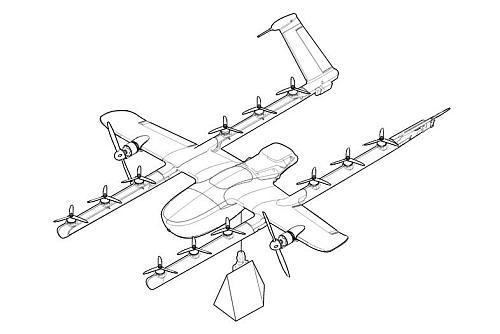
NASA considers bird-like drones to explore Venus’s atmosphere

NASA wants to study the use of drones that fly through the Venusian atmosphere and study the planet. BREEZE, or Bioinspired Ray for Extreme Environments and Zonal Exploration, will be funded for a two-year concept study. The BREEZE drones would be inflatable, fly at altitudes between 50-60 km, and ride zonal winds. This is one of 17 proposals under the NASA Innovative Advanced Concepts (NIAC) program.

Video: BREEZE | A Revolutionary Ray-inspired Airship Concept for Aerial Venus Exploration

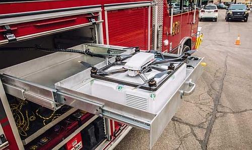
NCDOT launches national first with tethered drones on IMAP Trucks

Three years ago, in episode 285, we covered the Fotokite tethered drone and their partnership with Pierce Manufacturing. Now we see that the North Carolina Department of Transportation is launching a pilot with Fotokite. Some IMAP (Incident Management Assistance Patrol) vehicles will be fitted with tethered drones to provide situational awareness to the NCDOT Operations and Traffic Management Centers and assist with overall traffic management of the incidents.

Iris Automation receives FAA waiver to test BVLOS drones in Nevada river rescue missions

The Iris Automation waiver allows them to fly BVLOS in a rural, unpopulated area south of Reno, Nevada using the company’s Casia X detect and avoid system. Iris is working with the City of Reno and the Reno Fire Department (RFD) which conducts about 40 rescues per year at the Truckee River.

Killing drones with Thor’s hammer: Air Force eyes counter-UAS ‘Mjölnir’ weapon

The Air Force Research Laboratory (AFRL) has awarded a $26 million counter-UAS contract to Leidos. The company will build a prototype system that disables sUAS with high-power microwaves. Called Mjölnir, the name of Thor’s hammer, it builds on previous work under the Tactical High Power Operational Responder, or THOR, program. THOR is a counter-swarm electromagnetic weapon that uses non-kinetic energy to defeat multiple targets. In 2020, the Defense Department became so concerned it created the Joint Counter-Small Unmanned Aircraft Office, led by the Army.

Earth News: NASA is helping fly drones in the arctic — here’s what that means for sea ice and sea level change

NASA is leading a team to show that a fixed-winged drone could fly over the Arctic ocean for several days. The attritable UAS from Vanilla Unmanned is designed for multi-day surveillance and inspection operations. In this application, a drone with sensors can capture more accurate data than is the case with satellites.

Project Seeks to Build Drones to Supply Offshore Wind Farms

The drones would be customized to deliver supplies and other items to offshore wind farms in the Asia-Pacific region. Two Singapore-based companies signed an MOU to co-develop the drones: Marco Polo Marine Ltd., a regional integrated marine logistics company; and F-drones, developer of large autonomous delivery drones. The delivery drones are expected to reduce cost by 90 percent, be four times faster, and reduce carbon footprint.

Hobby drones at war: How do they help Ukraine?

In a February Facebook post, Ukraine’s Ministry of Defense says it is looking for drones and for pilots: “Do you own a drone? Give it to experienced pilots to use!” and “Do you know how to drive a drone? Join the joint patrol with units 112 of the separate brigade of the city of Kyiv!”

UAV Video of the Week

The PGA Tour is using drones to follow golf shots like this one from Rory McIlroy and it’s so cool

285 Tethered UAS for First Responders

An actively tethered UAS for situational awareness, a fixed-wing drone studies the atmosphere in Greenland, a larger “hive” drone releases a swarm of smaller “cicada” drones, Virgin Atlantic reports a drone near-hit, a drone that plants tree seeds, Wing receives FAA certification allowing delivery service in the US, and a drone powered by variable-buoyancy.

The Fotokite actively tethered UAS for first responders.

UAV News

Fotokite Launches Firefighter Situational Awareness System in Partnership with Pierce Manufacturing

The “Pierce Situational Awareness System by Fotokite” is an actively tethered UAS that integrates directly into public safety vehicles and firefighter operations. The Fotokite provides persistent aerial situational awareness and since they are tethered, no pilot licenses or authorizations to fly are required. The Pierce Fotokite systems have already been installed into Pierce fire apparatus, as well as command vehicles, and fire chiefs’ SUVs. The Fotokite Sigma Ground Station and Kite are available for first responders in general.

Black Swift UAS chosen for arctic research project in Greenland

The Institute of Arctic and Alpine Research, part of the University of Colorado Boulder, Is deploying Black Swift S2 drones from Boulder, Colorado-based Black Swift Technologies. They will conduct high-altitude, high-latitude atmospheric research studies in Greenland and create vertical profiles of the Arctic atmosphere. This will help understand how sublimation into the atmosphere affects climate conditions. The project is supported by the National Science Foundation and is part of the larger international East Greenland Ice-Core Project, or EastGRIP.

See NASA test a swarm of 100 US Navy Cicada drones

NASA’s Langley Research Center released a video showing four large “Hive” drones releasing over 100 smaller “Cicada” drones. The Cicada is a “Close-In Covert Autonomous Disposable Aircraft” and they fit in the palm of your hand. The Navy says, “Cicada is a concept for a low-cost, GPS-guided, micro disposable air vehicle that can be deployed in large numbers to ‘seed’ an area with miniature electronic payloads.” NASA is looking at the Cicadas as tools for meteorologists with sensors that measure temperature, air pressure, and wind-speed.

Video: It’s Raining Drones! NASA drops 100 drones tiny enough to fit in your hand

Virgin Atlantic jet carrying 264 passengers ‘came within SECONDS of crashing into two drones at 14,000ft as it approached to land at Heathrow’

The B787 Dreamliner with 264 passengers was flying at 320 mph over Essex when two drones were spotted. One drone was estimated to be 90 feet from the aircraft.

These tree-planting drones are firing seed missiles to restore the world’s forests

BioCarbon Engineering drones have been planting mangrove trees in Myanmar. The drones map the area, collect topography and data on soil condition, and combine that with satellite data. An analysis is performed that determines the best locations for the seeds, and the drone fires biodegradable pods into the ground. We had previously talked about a similar capability from Seattle-based DroneSeed.

Alphabet’s Wing becomes first drone delivery firm to win FAA approval in the US

As previously speculated, Alphabet’s Wing unit received Air Carrier Certification from the FAA. Wing is the first drone delivery company receiving this certification in the US, and it allows the company to start a commercial delivery service with drones. Wing plans to start the service in Blacksburg and Christiansburg, Virginia over the next few months. See also, Wing becomes first certified Air Carrier for drones in the US.

Wing package delivery drone.
Courtesy Wing.

Ultra-long endurance UAV flies using variable-buoyancy propulsion

The Phoenix ultra-long endurance autonomous UAV is powered by variable-buoyancy propulsion. It creates thrust by alternating between being lighter than air and heavier than air.
Researchers at the University of the Highlands and Islands in the UK use electrically-powered pumps and valves in the Phoenix.

Video: Phoenix: UK team trials first large-scale aircraft powered by variable-buoyancy propulsion.

UAV239 Recreational Drones for Commercial Purposes

Operators of recreational drones flying for commercial purposes, upset Google employees, arrests for illegal anti-drone systems, drone technology and the travel industry, UAS ID and tracking proposals, a business competition winner, mapping with a LIDAR-equipped drone, and an outdoor drone testing facility that is really indoors.

UAV News

NBAA Warns of Commercial UAS Violations

In UAS Operators Must Understand What Commercial Use Entails, the National Business Aviation Association (NBAA) expresses concern about “the unwelcome matter of recreational operators flying drones for compensation.” The organization is worried that some drone operators don’t understand what “commercial use” means.

3100 Google employees protest company’s involvement in Pentagon drone project

Google has been working with the United States Department of Defense under Project Maven, which applies machine-learning and AI to weapon systems. Google algorithms would analyze drone footage and identify objects. Some Google employees feel this violates the Google “don’t be evil” motto.

Swiss engineer arrested for illegal anti-drone system sales

Rome, Italy financial crime police arrested a Swiss engineer and an Italian entrepreneur for selling anti-drone systems. The systems can allegedly detect, track, and neutralize UAVs by jamming the communication signal as well as the global satellite navigation system.

Drones, phones changing way vacationers plan their trips

At the annual National Association of Broadcasters show (NAB), travel marketing experts envision the use of drones and VR technology to impact the $1 trillion travel industry.

FAA’s ARC Submits Recommendations On UAS ID and Tracking, Despite Lack of Consensus

While the UAS Identification and Tracking Aviation Rulemaking Committee (ARC) lacked complete consensus in the recommendations they sent to the FAA, some options were provided for UAS ID and tracking requirements. Reviews at the Department of Transportation and the Office of Management and Budget are pending.

Drone maker Fotokite wins $1 million Genius NY competition

Swiss-based Fotokite won the grand prize in the Genius NY business competition. Their fully autonomous tethered drone can stay aloft almost indefinitely. Applications include firefighting, law enforcement, broadcasting, and sports events.

Mentioned

LIDAR map for fully self-driving cars

Toll-road operator EastLink used a LIDAR-equipped drone to create a map of the inside of the Mullum Mullum tunnel. Future self-driving cars will require this detailed data.

Drone captures 3D LIDAR data for fully self-driving car trials in EastLink tunnel

University of Michigan opens up its M-Air UAV testing facility to students

The University of Michigan has opened the M-Air outdoor drone testing facility. Students and companies can use the five-story, 80 by 120 foot netted enclosure to test experimental algorithms and aircraft.

Ella Atkins | Drone Policy or Not?

Data Crunch Podcast

Deep research into niche artificial intelligence and machine learning industries.