Podcast: Play in new window | Download (Duration: 33:02 — 22.8MB)
The new Mavic Mini is so light that FAA registration is not required. Meanwhile, the US Department of the Interior has grounded Chinese drones, additional sensitive facilities have been added to the no-fly list, Uber Eats unveiled a delivery drone, a Navy submarine was resupplied by a drone, a white paper looks at drones at live broadcast events, and an airport welcomes drones – for facilities inspections.
UAV News
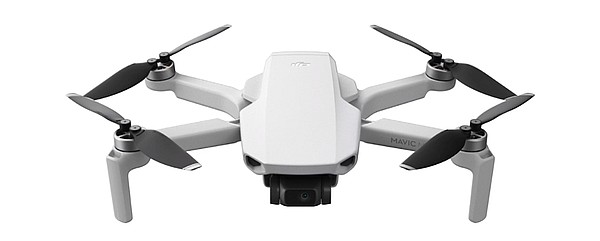
The Mavic Mini is DJI’s first drone that doesn’t need FAA registration
DJI says the new Mavic Mini is the smallest and lightest drone they have ever made. The “everyday flycam” weighs 249 grams, one gram under the threshold for FAA registration. With folding legs, creative shooting modes, automatic return to home, and up to 30 minutes flight time, the Mavic Mini shoots 1080p video at up to 60 frames per second from a three-axis gimbal. The quadcopter is available for preorder and will ship on November 11, 2019.
Entire drone fleet grounded by US government agency
The US Department of the Interior has grounded drones made in China, or that use Chinese parts. The Department has initiated a security investigation and depending on the results, the Department may resume drone flights. The Department of the Interior uses drones to inspect dams, inspect land, monitor environmental damage and endangered species, and aid emergency workers with wildfires, floods, and other natural disasters. The agency is concerned the drones could transmit images and video to China about key installations.
UAS Operations Restricted At More Federal Facilities
The FAA is restricting UAS operations over 60 additional Department of Defense and Department of Justice facilities. An FAA Notice to Airmen (NOTAM), FDC 9/7752, defines these special security instructions and the FAA UAS Data Delivery System has the restrictions, including a list of restrictions (National Security UAS Flight Restrictions) and a map of the restrictions (Map of FAA UAS Data). The FAA’s B4UFLY mobile app will also include the restrictions.
Here’s what the Uber Eats delivery drone looks like
Uber has unveiled the Uber Eats VTOL delivery drone with two rotating wings, each with three rotors. The maximum flight time is eight minutes over a 12-mile round trip delivery range. Uber doesn’t plan restaurant-to-doorstep delivery. Rather orders will be flown to predetermined drop-off locations and an Eats driver will make the “last-mile” delivery.
First Navy Submarine Resupplied By Commercial Drone
A small quadcopter resupplied the USS Hawaii (SSN 776), a fast attack submarine, one mile off Oahu, Hawaii. The 5-pound payload in this test included circuit cards, medical supplies, and food.
White Paper: Rethinking Drone Usage on Live Broadcasts
Drone use in live sports broadcasts hasn’t been as successful as some had hoped. Issues include the safety of spectators and athletes, the noise of drones, short flight times, and the need for immediate response during live broadcasts. The author explains why live motorsports may be a good application.
Drone collects runway maintenance data at Edmonton airport
At Edmonton International Airport, drones are becoming a regular part of safety inspections of runways, taxiways, and aircraft handling aprons. Canadian UAV services provider AERIUM Analytics has conducted about 3,000 drone flights at the airport over the past four years.