Podcast: Play in new window | Download (Duration: 42:07 — 24.2MB)
Subscribe: Email |
We talk with Dr. Ella Atkins about UAS privacy regulations, regulatory and legislative jurisdiction over the airspace, developing a drone safety culture, and UAS air traffic management challenges.
Guest
Dr. Ella Atkins is an Associate Professor in the Department of Aerospace Engineering at the University of Michigan, where she is director of the Autonomous Aerospace Systems (A2SYS) Lab.
 Ella received her BS and MS in Aeronautics and Astronautics from the Massachusetts Institute of Technology, and her MS and PhD in Computer Science and Engineering from the University of Michigan.
Her research focuses on task and motion planning, guidance, and control to support increasingly autonomous systems, with a focus on small UAS and aviation safety applications. She has an extensive history of successful collaboration with NASA.
Ella has authored over 150 journal and conference publications and has served long-term as an associate editor of the AIAA Journal of Aerospace Information Systems (JAIS). She has served on numerous review boards and panels, including the 2013 NRC committee to develop a research agenda for autonomy in civil aviation, the NRC Aeronautics Roundtable, NRC NASA Aviation Safety program review board, and Decadal Survey of Aeronautics (Panel E).
Ella is past-chair of the AIAA Intelligent Systems Technical Committee, AIAA Associate Fellow, IEEE senior member, small public airport owner/operator (Shamrock Field, Brooklyn, MI), and a private pilot. She serves on the National Academy’s Aeronautics and Space Engineering Board (ASEB) (2011-2017) and was a member of the IDA Defense Science Studies Group (2012-2013). She currently serves on the steering committee and as Graduate Program Chair to the new University of Michigan Robotics Program.
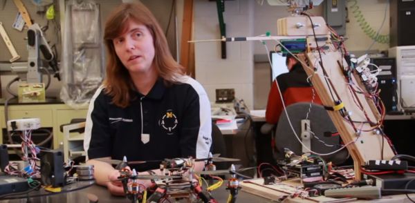
The Flying Robots video features Professor Ella Atkins describing the unusual unmanned aircraft that are being built at the University of Michigan Aerospace Department.
UAS Privacy Regulations
Should we create privacy rules specifically for UAS, rather than dealing with privacy more broadly? Privacy is already covered under existing ground-based laws, and new technology doesn’t necessarily imply a requirement for new laws.
A woman sunbathing topless on her private balcony says a quadcopter tried to take pictures of her.
Regulatory and Legislative Jurisdiction over the Airspace
Who controls what airspace: the federal regulatory agency or State or local communities? The FAA has claimed purview over all the airspace, but the U.S. Supreme Court in United States v. Causby stated that landowners own and control the “immediate reaches of the enveloping atmosphere” just above their properties. More discussion is needed about the low-altitude airspace and the ability of local communities to create their own standards based on their local situation.
In 2015, 45 states considered 156 bills that were related to drones. In total, 26 states have enacted drone laws, and six more states adopted resolutions.
Austin, Texas now requires a private pilot certificate to fly a UAV. However, one can fly if they have a document indicating permission from the property owner.
Developing a Drone Safety Culture
The lack of common-sense rules at any government level is resulting in anarchy. Manufacturers claim they can “stay out of legal trouble” by marketing to hobbyists who are unregulated and who don’t know where to fly.
Some solutions:
- Achieving a drone safety culture requires that manufacturers, commercial operators, and regular citizens learn responsible behaviors. “Know Before You Fly” will gradually catch on once we make it through a generation that grows up with drones.
- Creating “drone parks” in urban areas would give people a place to freely fly. Right now hobbyists really don’t have guidelines of where to go (apart from rural AMA fields which were typically designed for fixed-wing model aircraft) so they fly wherever they like.
- Focus separately on “safety” and “privacy,” otherwise the solutions may not make sense. For example, it may be safe to fly over a large open field, but the landowner may not want to be filmed at low altitude. Or, everyone might want great aerial views of a public concert in the park, but such flights are very risky until we are really confident the drones won’t have problems and crash into the crowds.
University of California, Berkeley researchers have developed LightCense, a low altitude identification system for drones. The hope is that it would make drone operators more accountable.
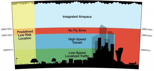
Air Traffic Management
Recent proposals for management of unmanned commercial traffic involve altitude layering. But those do not contemplate the immediate reaches above the landowners, or what may be on the ground below.
This presents challenges, such as dealing with commercial drone entries into immediate reaches (landowner-controlled) airspace, and integrating drones into airspace clearly needed for manned flight operations. It may be appropriate to reconsider the 500 foot altitude line of demarcation, and also to add an “immediate reaches” layer.
A “drone highway in the sky” would not necessarily follow a ground-based road network. The real question is whether a low-altitude “highway in the sky” would be designated and “taken with compensation” like our ground-based roads, or whether the “sky” will be “taken without compensation.”
Compounding the difficulties in resolving these issues is the problem that people are very polarized – they either “love” or “hate” drones. A more informed public view would almost certainly be more moderate and reasonable.
University of Michigan
The University of Michigan offers opportunities for both undergraduate and graduate students: student team competitions, undergraduate or graduate research projects, and course projects.
Design and use of UAS can be found in the engineering, aerospace, robotics, and computer science departments. Others such as civil engineering, architecture, biology, and journalism do not design UAS or their software, but they have begun to use UAS to support their research and education activities.

![NASA UTM Chart]](http://utm.arc.nasa.gov/images/utm-chart.png)