
Podcast: Play in new window | Download (Duration: 27:30 — 19.0MB)
 This Episode:
A visual drone census map, who should develop privacy laws that govern drones, the Hydra proposal for drones at sea, surveying Australia with sUAS, and unmanned F-16 target drones.
The News:
Drone U. Releases US Drone Census
Drone University, an online educational platform, has created a U.S. Drone Census map showing the “complex ecosystem of users, industry, legislation, and research.” You filter the points on the map by selecting categories from a dropdown, like DIY Drone Groups, Academic Programs, and FAA test Site Applicants.
Should states determine if drones can record your conversations?
U.S. courts have held that the First Amendment protects the “right to record,” but this is not firmly established.The scope of the “right to record” is very much open. Recordings by drones adds a new twist to the debate, but we should not rush to legislation.
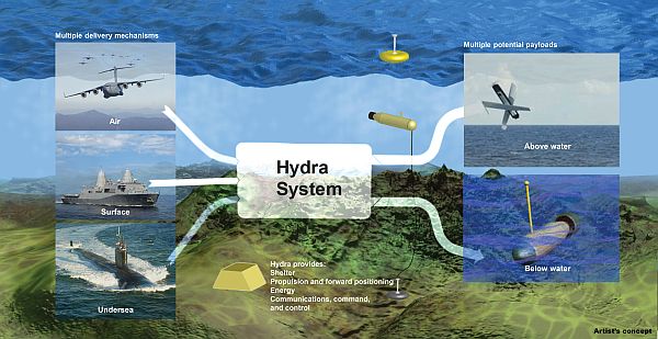
DARPA’s Plan to Flood the Sea With Drones, Carrying More Drones
The DARPA idea is to develop an undersea network of sites (called Hydra) from which drones can be quickly launched in response to world events that need immediate attention, like natural disasters and piracy.
UAV applications for the survey, mining, agriculture, and civil construction industries can be accomplished with fixed wing or rotary aerial vehicles. Fixed wing is good for aerial mapping, rotary for inspections or difficult to access locations.
Boeing, USAF Complete First Unmanned QF-16 Flight
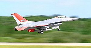
Boeing QF-16
The first flight of a remotely piloted Lockheed Martin F-16 fighter jet was successful. Two Air Force ground pilots launched the QF-16, took it to 40,000 feet, and performed some aerial maneuvers, including a 7G barrel roll. In USAF parlance, this is not a Drone it is a FSAT or Full Scale Aerial Target. Video: On Target: F-16 flies with an empty cockpit.