Tag Archives: DHS

337 Hacking Drones

Hacking drones as a target and as a weapon, military drone flight over San Diego, a State-by-State drone report card, a milestone in India for civilian drones, the EHang 216 goes sightseeing, and those drone sightings in the U.S. midwest, revisited.

UAV News

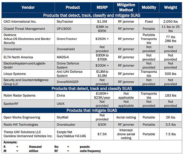
Drones Aren’t Just Hackers’ Targets – They’re Hackers’ Weapons

A 96-page report titled How to Analyze the Cyber Threat from Drones [PDF] has been published by the Rand Corporation. The report summarizes 26 specific instances of hacking drones. The most common cyberattacks reviewed were denial of service and spoofing attacks against an active drone. The Rand Corporation recommends:

  • DHS must continue to work with senior policymakers, cybersecurity experts, and other government and law enforcement agencies to move towards a coherent UAS cyber strategy.
  • DHS should also prioritize the most critical vulnerabilities and find ways to close attack vectors and protect attack surfaces.
  • DHS will need to monitor UAS adoption and anticipate the implications of widespread UAS diffusion.

Secret General Atomics Drone Flights Over San Diego Raise Surveillance Concerns

The press reported that a new version of the Predator drone (the SkyGuardian) would be flying over San Diego. The General Atomics SkyGuardian has an advanced detect-and-avoid system with a Due Regard Radar to detect other aircraft, TCAS (Traffic alert and Collision Avoidance System) for detecting nearby aircraft transponders, and ADSB (Automatic Dependent Surveillance-Broadcast) which broadcasts the drone’s location.

Which States Are Prepared for the Drone Industry?

The authors argue that states should take the lead by creating drone highways that mirror the paths of the public roads beneath them. The “Fifty-State Report Card” ranks states on their readiness to get new drone technology into the skies. The ranking considers airspace lease law, law vesting air rights with landowners, and navigation easement law, as well as having an aviation advisory committee and the estimate for drone jobs. North Dakota ranks #1 and #50 falls to South Carolina. This is from the Mercatus Center, associated with George Mason University.

India’s First NPNT Compliant Drone Flight Successfully Completed

India’s first No-Permission No-Takeoff (NPNT) compliant drone flight was successfully completed. India’s Ministry of Civil Aviation and the Directorate General of Civil Aviation banned civilian use of UAVs in 2014, but in 2018, a new policy became effective. UAVs had to comply with stringent manufacturing standards and also be compliant with the new No-Permission No-Takeoff (NPNT) architecture requiring a Unique Identification Number (UIN), an Unmanned Aircraft Operator Permit (UAOP), online permission for every flight, and compliance workflow through a fully digital “Digital Sky” portal. This Digital Sky platform was demonstrated with an A200 Remotely Piloted Aircraft System (RPAS)

EHang 216 Sightseeing Flights

EHang released a video showing an EHang 216 autonomous aerial vehicle (AAV) conducting aerial sightseeing trial flights in Yantai, a coastal city in East China. Passengers flew around Yantai’s Fisherman’s Wharf in trials that are part of a “world flight tour.” EHang founder and CEO said, “As the world’s first provider of passenger-grade AAVs, we are honored to prove this game-changing air mobility solution by demonstrating flights to regulators, customers, partners and the general public. The positive support and feedback have strengthened our determination in our quest to bring this new style of mobility to the people.” 

Video: Self-flying EHang 216 Showcases Aerial Sightseeing Trips Over the Sea in East China

Newly Released FAA Documents Give Unprecedented Look Into Colorado Drone Swarm Mystery

In December 2019 and January 2020, law enforcement agencies reported seeing drones flying at night in formations in parts of Colorado, Nebraska, and Kansas. The sightings made national news, but we never got a really good idea what (or who) was behind this. Now a volunteer researcher with the Scientific Coalition for UAP Studies (SCU) used the Freedom of Information Act (FOIA) to obtain hundreds of pages of emails and other documents from the FAA and other federal agencies. Hundreds of other documents are still being processed by the FAA and some documents are being withheld by the FAA. The agency says they are exempt from FOIA.

Kespry Appoints Krishnan Hariharan as Vice President of Engineering

Kespry announced the appointment of Krishnan Hariharan as Vice-President of Engineering overseeing Kespry’s Aerial Intelligence platform development and evolution. Hariharan was Vice-President, Engineering and Product Management for PrecisionHawk. Before that, he held a number of leadership roles at SAVO, Sabre, and OpenText. He also founded River North Labs, a technology consulting company.

310 Hexa Electric VTOL

Rides available in the Hexa Electric VTOL, mapping a railway project, low-altitude hurricane hunting, another reported drone strike, a DHS warning for private industry, another round of financing for PrecisionHawk, and spying on hippos with drones.

The Hexa electric VTOL passenger drone. Courtesy Lift Aircraft.

Lift Aircraft says 13,000 people have signed up for drone rides; flights begin in beta mode in Texas

In 2020, Lift Aircraft plans a 25-city tour of it’s Hexa electric VTOL passenger drone. You can register for a flight on Lift’s website. It will cost $149-$249 depending on flight duration. The 432-pound electric VTOL uses 18 independent electric motors and propellers and is controlled through a triply redundant autopilot computer and a single 3-axis joystick. Or you can tap on the seven-inch touchscreen for a “Look mom, no hands!” mode.

Flying the Hexa electric VTOL passenger drone.

What if? Norfolk Southern develops effective UAV program, but it did not come without some trial and error

Norfolk Southern Railway asked themselves if they could use lower-cost UAVs to image project areas and stitch them into survey-grade 3D mosaics for the project team. They formed a UAV field team, got a Part 107 license, and designated a 5-mile linear project. What they learned will help them (and others) in future projects.

Drones Provide a New Frontier in Hurricane Observations

Hurricane hunters fly through hurricanes, but not at sea level where the winds are strongest. Scientists flew expendable Raytheon Coyote drones as low as 360 feet into several hurricanes and measured atmospheric conditions in winds as high as 194 miles per hour. These were deployed NOAA’s P-3 reconnaissance aircraft. The Coyote UAS is adaptable for a variety of missions including surveillance, electronic warfare and strike. A swarm of Coyote drones has successfully flown and demonstrated autonomous networking. A paper was recently published in the Bulletin of the American Meteorological Society: “Eye of the Storm: Observing Hurricanes with a Small Unmanned Aircraft System.”

AIR7 HD struck by suspected drone over downtown LA, makes precautionary landing

Los Angeles ABC affiliate KABC reports that their helicopter was struck midair by an object. At first, the pilot and reporter thought it was a bird strike but after landing and inspecting the damage to the helicopter tail, they believe it was a drone strike. The incident occurred at 7:15 pm, flying at 1100 feet.

DHS Continues to Warn Private Industry Against Using Foreign-Made Drones

In late November, the FBI’s Cyber and Infrastructure Security Agency issued a bulletin to private industry warning about the risk of exposing private data when using UAS manufactured abroad. The bulletin warns of possible data compromise when operating UAS “designed, manufactured, or supplied abroad where the data is stored, transferred to, or accessible by servers in a foreign country.”

PrecisionHawk Raises $32 Million to Advance Next Phase of Growth in Commercial Drones

PrecisionHawk announced $32 million in funding by a group of venture investors. The company says this will allow them to innovate with their PrecisionAnalytics A.I.-powered aerial data analytics platform, accelerate sales initiatives, and support further market expansion. In total, PrecisionHawk has raised $130 million from leading venture capital firms. See also, We’ve Raised $32 Million to Build the Next Generation of Drone Software and Services.

Spying With Drones to Help Hippo Conservation Efforts

University of New South Wales conservationists used drones to monitor threatened hippos in Africa. They used a DJI Phantom 4 to film the hippos from a safe distance. The wild hippo population is declining because of habitat loss, and hunting for meat and ivory. They are under-studied because they are nocturnal, amphibious and aggressive.

289 UAS Threat to Critical Infrastructure

DHS resources for the threat of UAS to critical infrastructure, urban testing of drone flights in Reno, using drone images as evidence, a delay for the remote ID NPRM, and a drone used by the Army Corps of Engineers.

UAV News

‘We’re Not Being Paranoid’: U.S. Warns Of Spy Dangers Of Chinese-Made Drones

NPR references the DHS Cybersecurity and Infrastructure Security Agency (CISA) website Unmanned Aircraft Systems (UAS) – Critical Infrastructure. It contains a video describing the UAS threat to critical infrastructure, as well as a description of what the threat is, why the threat is important to critical infrastructure, actions critical infrastructure organizations can take, available DHS UAS resources, and contact information.

Video: UAS and Critical Infrastructure – Understanding the Risk

NASA’s First-Of-Kind Tests Look To Manage Drones In Cities

Tests in downtown Reno have included an autonomous drone flight from one rooftop of a five-story parking garage to a roof across the street. The drone adjusted itself for gusty winds. In another test, drones approached each other and avoided colliding. The drones have onboard software for landing, avoiding crashes, surveillance, detection, and identification. Ground system software communicates flight plans and positions to other software systems. The Nevada Institute of Autonomous Systems is conducting the Reno tests.

Man says neighbors used drone footage in court against him

A man in Indiana bought a 35-acre property in 1985, but his new neighbors didn’t like what he was doing on his own land. The neighbors complained to the county accusing him of violating county ordinances. Apparently, they flew a drone over the property taking pictures as evidence. The property owner says they had to be BVLOS to get those pictures.

Remote ID Regulations For Unmanned Aircraft Systems (UAS) Are Delayed Until September 2019

The Notice of Proposed Rulemaking (NPRM) for Remote Identification of UAS was scheduled for July 2019. The Office of Information and Regulatory Affairs says the NPRM will instead be issued in September 2019. This comes from the May 22, 2019 OIRA publication of the Trump Administration’s Unified Agenda of Regulatory and Deregulatory Actions.

UAS adds cutting-edge capabilities for Corps projects

The U.S. Army Corps of Engineers Sacramento District has begun using a Microdrones quadcopter. The District’s 4-person UAS team has been trained by Microdrones. Two of them are Part 107-certified UAS pilots. Applications include video footage and photos for the Public Affairs Office, creating detailed site maps, and high-resolution 3-D images for team members and partner agencies.

md4-1000, courtesy Microdrones.

Microdrones to Host GeoDays 2019, June 12 – 14

Microdrones is hosting GeoDays 2019 at their location in Germany. They’ll be conducting flight demonstrations and explaining how to integrate surveying, mapping, LiDAR, and inspection into your business.

Mentioned

Drones: Latest incidents around the world – A map highlighting the latest drones incidents around the world has been published as part of the Countering Drones Conference, taking place July 9-11, 2019 in London, UK.

Opinion piece: Risk, regulation and resilience in countering drones – A report you can download on risk and regulation around drones.

288 Recreational Drone Restrictions

The FAA has new recreational drone restrictions, along with exceptions for those that cannot be presently met. Also, drones that identify polluting ships, data security fears for Chinese drones, professional sports leagues weigh-in on drones, UAS that measure environmental conditions for weather prediction, and states in the US are actively using unmanned aircraft.

UAV News

FAA Implements New Recreational Drone Restrictions

The FAA Reauthorization Act of 2018 repealed the Special Rule for Model Aircraft and replaced it with “new conditions to operate recreational small unmanned aircraft without requirements for FAA certification or operating authority.” Recreational drone users must meet eight statutory conditions. However, since the FAA cannot implement all of them immediately, exceptions were published in the Federal Register May 17, 2019, as Exception for Limited Recreational Operations of Unmanned Aircraft.

The eight conditions, and where exceptions apply:

1. The aircraft is flown strictly for recreational purposes.

2. The aircraft is operated in accordance with or within the programming of a community-based organization’s set of safety guidelines that are developed in coordination with the FAA.

The Act requires the FAA to establish guidelines for recognizing community-based aeromodelling organizations (CBOs). Since those guidelines don’t exist and CBOs thus cannot be recognized, the FAA will allow “operations conducted in accordance with existing safety guidelines of an aeromodelling organization.” As an alternative, the basic safety guidelines published in faa.gov/uas are sufficient. But, you “should be able to explain to an FAA inspector or law enforcement official which safety guidelines you are following if you are flying under the exception for limited recreational unmanned aircraft operations.”

3. The aircraft is flown within the visual line of sight of the person operating the aircraft or a visual observer co-located and in direct communication with the operator.

The visual observer is optional unless flying FPV and the operator can’t see the surroundings.

4. The aircraft is operated in a manner that does not interfere with and gives way to any manned aircraft.

5. In Class B, Class C, or Class D airspace [controlled airspace] or within the lateral boundaries of the surface area of Class E airspace designated for an airport, the operator obtains prior authorization from the Administrator or designee before operating and complies with all airspace restrictions and prohibitions.

Until Low Altitude Authorization and Notification Capability (LAANC) is upgraded to enable recreational flyers to obtain automated authorization to controlled airspace, the FAA is granting temporary airspace authorizations to operate at certain fixed sites that are established by an agreement with the FAA. The list of authorized fixed sites is available on the FAA’s website.

6. In Class G airspace, [uncontrolled airspace where the FAA does not provide air traffic services] the aircraft is flown from the surface to not more than 400 feet above ground level and complies with all airspace restrictions and prohibitions.

7. The operator has passed an aeronautical knowledge and safety test and maintains proof of test passage to be made available to the Administrator or a designee of the Administrator or law enforcement upon request.

The test doesn’t yet exist. Recreational flyers who adhere to the other seven conditions may use the exception for limited recreational unmanned aircraft operations.

8. The aircraft is registered and marked and proof of registration is made available to the Administrator or a designee of the Administrator or law enforcement upon request.

Registration and marking requirements are published and an online registration process is in place. Each unmanned aircraft used for limited recreational operations must display the registration number on an external surface of the aircraft. Proof of registration must be available upon request.

Sniffer Drones Will Start Patrolling the World’s Busiest Shipping Ports

New regulations apply to air pollution from ships, specifically sulfur oxides. Drones are being tested or used in ports around the world. These will quickly fly through a ships exhaust plume and measure the emissions. If a “dirty” ship is encountered, that vessel can be singled out for a test of its fuel. The Skeldar V-200 drone is an example.

DHS warns of ‘strong concerns’ that Chinese-made drones are stealing data

The US Department of Homeland Security issued an alert through the Cybersecurity and Infrastructure Security Agency that says the drones “contain components that can compromise your data and share your information on a server accessed beyond the company itself.” Further, that “…certain Chinese-made (unmanned aircraft systems)-connected devices capable of collecting and transferring potentially revealing data about their operations and the individuals and entities operating them, as China imposes unusually stringent obligations on its citizens to support national intelligence activities.”

DJI said that it gives customers “full and complete control over how their data is collected, stored, and transmitted,” adding that “customers can enable all the precautions DHS recommends.”

Drones And Sports? Pro Leagues And NCAA Weigh In

Through the NPRM commenting process, the NFL, MLB, NASCAR, and NCAA have expressed concerns. The Leagues want to see the rules explicitly state that UAS operations at night comply with rules applicable to aircraft. Also, they want to see the requirement that pilots make their credentials available to law enforcement expanded to include private security officials.

States turn to drones to predict avalanches, spot wildlife

The American Association of State Highway and Transportation Officials found all but one State public transportation agency was using drones. (Rhode Island wasn’t, but since then they bought a drone.) In 2016, no state transportation agency was using drones every day. Now, 36 states have certified drone pilots on staff.

Researchers test unmanned aircraft systems for measuring the lower atmosphere, potentially improving short term weather forecasts

This is a project with the National Severe Storms Laboratory, the University of Oklahoma, the University of Colorado, and Meteomatics. Researchers used fixed-wing and rotary small UAS in Oklahoma to test the value of UAS for observing local environmental changes that can lead to severe thunderstorms.

Video of the Week

Beautiful! Drone footage captures school of stingrays swimming off coast of Australia

276 Drones for Wildlife Management

Using drones for wildlife management and conservation: bears and drone noise, elephants and poachers, Kakapos and artificial insemination, and STEM drone projects to protect wild and endangered animals. Also, DHS and the Northern border, an Iranian drone, and a base jumping video.

UAV News

Bears Are Getting Used to Drones

A new study in Conservation Physiology notes that unmanned aircraft systems are being used around wildlife for recreation, research, and conservation. To learn about the potential stress to animals, they flew drones over Minnesota black bears five times a day, twice a week.

How eavesdropping on elephants is keeping them safe

In some areas, elephants are endangered by high levels of poaching. Researchers believe understanding elephant calls will help improve their survival rate. They are using AI (deep learning) to decipher recordings of the elephants. Drones are being used to collect data and identify poachers.

Tweet from Dr. Andrew Digby

The Kākāpō is a large, flightless, ground-dwelling parrot found in New Zealand. Kākāpō Recovery combines the efforts of scientists, rangers, volunteers, and donors to protect the critically endangered bird.

2019 International STEM Youth Innovation Competition

This event for students under the age of 18 is organized by the British International Education Association (BIEA), and supported by the British Science Association, the Royal Institution, and the Royal Air Force Museum. Teams design and develop drones used for protecting wild and endangered animals. The submission deadline is March 31, 2019. Video: BIEA 2018 Drone Design Competition.

DHS Planning Drone Mitigation and Tracking Evaluations Later This Year

The Department of Homeland Security wants to detect, track, and identify small unmanned aircraft systems, ultralight aircraft, and small manned aircraft, below 500-feet along the Northern Border. The DHS Science and Technology Directorate plans to release a Request for Information from vendors.

Iran’s latest homemade drone resembles orange whale… and won’t be winning any stealth technology awards

The Khodkar is equipped with two cameras, one mounted on the front and another below the main body. It bears a striking resemblance to a very old jet.

Video of the Week

Via Tim Trott: GoPro Awards: BASE Jumping with FPV Drone in 4K. A base jumping session captured by Jan Verhaeren, winner of the of the GoPro Million Dollar Challenge.

UAV229 DroNet Autonomous Flight Through Cities

DroNet uses deep machine learning for autonomous flight, a labor union takes a stand on package delivery by drone, a tiny radar for sUAS, counter-unmanned aerial systems, and a British drone survey.

DroNet: Learning to Fly by Driving

DroNet: Learning to Fly by Driving

UAV News

AI-Powered Drone Mimics Cars and Bikes to Navigate Through City Streets

Researchers have developed a drone that can autonomously fly through the streets of a city. DroNet uses minimal onboard sensing and is trained with datasets collected by cars and bicycles.

Two years ago, roboticists at the University of Zurich trained a deep neural network with photographs taken by cameras mounted on a hiker’s head. They could then fly a drone along forest paths. Now, along with researchers from a Madrid University, they have used city datasets to train the rules for navigating through streets without running into anything.

DroNet is a convolutional neural network, designed as a fast 8-layers residual network. It produces two outputs for each single input image: A steering angle to keep the drone navigating while avoiding obstacles, and a collision probability to let the drone recognize dangerous situations and promptly react to them.

The researchers publicly release all their datasets, code, and trained networks. Learn more at the DroNet project website, and the research page on deep learning. See also the video DroNet: Learning to Fly by Driving.

No parcel drones. No robo-trucks – Teamsters driver union delivers its demands to UPS

The Teamsters union and UPS are holding labor negotiations that cover 260,000 union workers in North America. Reportedly, one of the union demands is a prohibition on “driverless trucks, drones, robots, and other driverless technology.” In Teamsters Union Says ‘No’ to UPS Drones, we find this:

“With a smaller carbon footprint and ever-increasing sophisticated, AI-infused behavior, it makes sense to transition to individual aerial deliveries, not to mention the convenience on behalf of the customer. On the other hand, one completely understands and empathizes with the aversion truck drivers have toward this stark, autonomous future. If it feels like their jobs are being endangered by the incredible exponential growth in technology, it’s because they are. Hence, a series of discussions soon to be cemented into policy, with one side trying to slow things down in order to survive, and another eager to march into the fully autonomous future.”

Aurora Flight Sciences and Socionext Develop Radar-Enabled Collision Protection Solution for Drones

Aurora Flight Sciences is collaborating with Socionext Inc. on a Radar Flight Control Module that exists as a single-chip 24GHz radar. It includes range measurement software and the radar can detect multiple objects, objects in open spaces, and target distance and speed. The RFCM talks to the flight controller and provides distance, warning and braking signals, preventing head-on collisions with obstacles. Press release: Aurora Flight Sciences and Socionext Develop Radar-Enabled Collision Protection Solution for Drones [PDF].

DHS SAVER Program Issues ‘Counter-Drone’ Procurement Guide for Emergency Responders

The DHS National Urban Security Technology Laboratory (NUSTL) System Assessment and Validation for Emergency Responders (SAVER) program conducted a market survey of counter-unmanned aerial systems. The 19 page Market Survey Report: Counter-Unmanned Aerial Systems [PDF] is intended to assist emergency responders in identifying useful products.

The thirteen systems identified range in price from $7,500 to $1.9 million. Eight systems can detect, track, classify and mitigate SUAS; two systems can detect, track and classify SUAS; and three systems can mitigate SUAS.

Counter-Unmanned Aerial Systems

Market Survey Report: Counter-Unmanned Aerial Systems. Source: DHS.

Driving licence for DRONES supported by majority of Brits, while 1 in 5 call for total ban

In a study commissioned by a UK tech firm Nominet, more than 2,000 British adults were surveyed. Nearly three-quarters of the respondents believe that flying a drone should require the equivalent of a driving licence. Thirty-seven percent said the Government should set up a body to manage drone ownership.


UAV202 Piaggio HammerHead Testing Resumes

A year after the crash of the prototype, testing of the Piaggio HammerHead UAS is underway again. We also look at drones and field biology, security, and swarming technology.

The Piaggio Aerospace P.1HH HammerHead

The P.1HH HammerHead UAS, courtesy Piaggio Aerospace.

UAV News

Piaggio Aerospace Resumes Test Flights of Hammerhead UAV

In May 2016, the prototype Piaggio Aerospace P.1HH HammerHead UAV crashed off the coast of Sicily. Reportedly, there were flight control system integration problems. Testing has now resumed and eight systems are to be delivered to the United Arab Emirates. The MALE (Medium Altitude, Long Endurance) Hammerhead is derived from the Piaggio P.180 Avanti II business aviation aircraft, a twin turboprop pusher aircraft.

Drones hunt down rare plants in Hawaii by going where people can’t

GIS specialist Ben Nyberg is the lead drone pilot for the National Tropical Botanical Garden. While flying a drone at a 1,000-acre preserve in Hawaii, he discovered a very rare plant on a steep, inaccessible cliff. Less than 25 of these plants were thought to exist. With the drone, they discovered about 10 more of these plants, as well as several other critically endangered plants.

Homeland Security concerned about commercial drones being used for ‘nefarious purposes’

According to a Department of Homeland Security (DHS) spokesperson, “DHS does consider commercial drones configured or modified to employ explosives or weapons a concern. This is due to low-cost, ease of access, and the quick-pace of this evolving technology to adapt beneficial Unmanned System equipment for nefarious purposes.” The US Army has published a 13-page document, Counter – Unmanned Aircraft System Strategy Extract [PDF].

USAF calls for drone defences after F-22 overflight

Drones are being spotted around military aircraft in the U.S. and the Air Combat Command has no authority to deal with them. It’s a civil authority that has to be granted first before it can be executed by military forces.

DJI Is Locking Down Its Drones Against a Growing Army of DIY Hackers

People have found ways to get around DJI’s flight restrictions and they’ve published the exploits online. DJI updated their software to break the hacks, but that just leads to another round in the battle.

Micro Systems Develops New Drone Swarming Technology

Kratos Defense and Security Solutions subsidiary Micro Systems announced its WOLF-PAK swarming technology. There is no centralized control system and the swarm of autonomous vehicles follows a leader vehicle. Vehicles recognize and locate each other and keep a predefined distance apart.

WOLF-PAK demonstration video:


Walmart commissioning Griffiss for drone delivery research

Walmart has reportedly been working with one of the UAS test sites to develop drone-based package delivery. But now the retailer is additionally engaging the UAS test site in upstate New York.

Mentioned

The DronesGlobal Slack Team is a members-only Slack team “for commercial drone operators, manufacturers, buyers, suppliers and experts from around the world.” There is a one-time fee of $49 and applications are subject to approval.

Your AOPA membership will get you 20% off the Drone World Expo conference or a free Expo pass. To be held October 3-4, 2017, at the San Jose Convention Center in the Capital of Silicon Valley.

Can I fly there? Is a drone safety app from CASA. It reflects the standard operating conditions for those flying their drone commercially (under the excluded category of commercial operations) and is a valuable educational and situational awareness tool for both commercial and recreational drone flyers.

XKCD provides another good drone comic.

FlytBase Inc. is a Silicon Valley startup creating developer tools for intelligent and connected commercial drones. They say their FlytBase Cloud platform helps developers connect drones with cloud-based business applications over a real-time secure link. It provides access to real-time drone control, telemetry and payload data.

FlytBase Cloud: Internet of Drones Platform