Tag Archives: AirMap

389 A Perching Drone

A perching drone saves battery power, drones that connect communities, considerations for photography drones, Covid vaccination deliveries, secret combat drones, breaking up street racing, Airmap acquires DroneUp, and NOTAMs and drones.

UAV News

Watch this falcon-esque drone perch and carry objects like a bird

Engineers at Stanford University created robotic talons that can be attached to a drone so it can perch and carry objects like a bird. The SNAG (Stereotyped Nature-Inspired Aerial Grasper) has two independently moving legs inspired by the peregrine falcon. The 3D-printed “bones” articulate with motors and fishing lines that act like muscles and tendons.

The legs and claws of the perching drone grasp quickly, in no more than 20 milliseconds. When the SNAG accelerometer detects an impact with the perch, it activates a balancing algorithm and tilts the drone forward, just like a bird does.

Video: Stanford engineers create perching bird-like robot

Drones on Cape Cod: Skyports and MassDOT Partner to Connect Remote Communities

The Massachusetts Department of Transportation’s Aeronautics Division has partnered with Skyports to investigate connecting remote Cape Cod communities. The Department wants to provide emergency medical delivery after storms or other natural disasters and everyday services such as healthcare and logistics. Cape Cod is composed of difficult-to-reach islands and peninsulas.

6 Important Things To Consider Before Buying A Drone For Photography

  1. Style of the Drone
  2. Flying Range and Battery Life
  3. Flight Control System and Transmitter
  4. Is Raw or DNG Format Support Necessary?
  5. Camera Quality and Support
  6. Safety Features and Intelligent Functions

India tests drone delivery of COVID-19 vaccine in remote Jammu

Vaccine deliveries in remote regions can be problematic. But in India where the travel time can be two hours by road, a multirotor drone can make the same trip in 20 minutes. India’s CSIR-National Aerospace Laboratories has developed the octocopter that can carry a 10-kilogram payload over a range of 20 kilometers.

Two New Secret Drone Programs Could Emerge In The Air Force’s Next Budget Proposal

Development money for two classified unmanned air combat vehicles is planned for the 2023 fiscal budget. The combat drones would be designed to operate alongside the Next-Generation Air Dominance Program (NGAD) and the B-21 bomber, both classified programs. Teal Group’s Richard Aboulafia speculates this could be Skyborg – the loyal wingman program. See also, 2 new secret combat drones are in the works, Air Force secretary says.

Drones used to make street racing bust in South Fulton

Street racing has been a problem in South Fulton, Georgia. Now the City of South Fulton Police Department is using drones to watch for street racing, document the activity, and capture images of license plates and the individuals involved. So far 33 people have been charged and four vehicles confiscated.

DroneUp Acquires Airmap: Another Move Towards Drone Ops on a Very, Very Big Scale

DroneUp is a drone services provider with a trained pilot network, proprietary software, and a relationship with Walmart that includes a financial investment and a drone delivery operation. AirMap has an Unmanned Aircraft System Traffic Management (UTM) service which supports as many as 100,000 flights per day. Together, the companies can scale up operations and position for future BVLOS flights.

Name change signifies a bigger mission for NOTAMs

The meaning of the acronym NOTAM has changed from “Notice to Airmen” to the gender-neutral “Notice to Air Missions.” The new acronym now easily applies to the un-crewed flights of free balloons and drones.

UAV Video of the Week

Video: Beautiful drone footage of tree-lined NY roads and geometric fields | SWNS

This beautiful aerial footage takes you above a winding country road and geometric fields under the setting autumn sun. From the UK journalism team at SWNS.

332 Last-Mile Drone Delivery Tested

A major test of last-mile drone delivery, direct-seeding rice with a drone, a drone-centric kiosk you can build yourself, and a webinar to learn the BVLOS regulatory landscape.

UAV News

Last Mile Drone Delivery: Testing the Limits of Commercial Operations

DroneUp partnered with Virginia’s Center for Innovative Technology (CIT) and UPS on a project to quickly evaluate the concept of last-mile drone delivery. They wanted to see how unmanned aerial systems could assist with critical delivery during times of crisis.

On the vacant campus of St. Paul’s College, in Lawrenceville, Virginia, a group of pilots flew over 200 flights under a scripted plan, operating under part 107 rules, with industry-standard drones. The flights simulated the delivery of 1.275-pound payloads of medical and other critical supplies in city-like conditions. Data was collected with respect to operational capacities, airspace deconfliction, operator safety, processes, policies, and training.

Tom Walker, DroneUp’s CEO, said, “DroneUp’s drone delivery exercise was aimed at learning what is possible to do safely and effectively today while gathering data to overcome seemingly impossible obstacles in the near future.” 

For more, see the 56-page report, DroneUp Resources Operation Last-Mile: Critical Drone Delivery Report.

XAG Introduces Rice Seeding Drone

XAG is a Chinese company focused on agricultural technology. In April 2020, they organized a rice direct-seeding demonstration where two workers spread 5kg of rice seeds through a muddy rice paddy. Following that, a XAG drone repeated the same task. The difference in planing time was significant.

Raspberry Pi-based Kiosk Display Shares Weather, FAA Advisories for Drones

A project from Sky Horse Tech uses a Raspberry Pi to power a custom drone-centric kiosk. The kiosk pulls in local weather data and FAA advisories through AirMap and MapBox. The data cycles every 30 seconds and is refreshed every 5 minutes. The kiosk uses a 32” display, a $35 Raspberry Pi 3 Model B or newer, some free software, and weather and FAA advisory APIs.

Navigating the Regulatory Landscape Towards BVLOS Operations

This free AUVSI webinar is scheduled for Wednesday, June 10, 2020, 03:00 PM TO 04:00 PM (EDT). You’ll learn about the regulations affecting Beyond Visual Line of Sight (BVLOS) drone flight and the factors involved in successfully navigating the regulatory environment to achieve a waiver. 

Iris Automation director of airspace integration Trever Linn will explain what operators should expect before applying for a waiver, and the key components such as risk mitigation measures and CONOPS documentation necessary for approvals. Attendees will learn about current regulatory challenges, readily available solutions, and the path forward for BVLOS drone operations.

UAV235 The Cora Electric Air Taxi

Testing the Cora electric air taxi in New Zealand, drone research at Ford, package delivery in the UK and in the U.S., UAS traffic management in Switzerland and in the U.S.

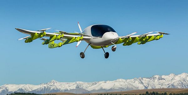
The Cora electric air taxi in-flight in New Zealand.

The Cora electric air taxi in-flight in New Zealand. Credit: Richard Lord, via Kitty Hawk.

UAV News

Larry Page’s Flying Taxis, Now Exiting Stealth Mode

The Kitty Hawk company calls Cora “your first step towards everyday flight.” Financed by Google co-founder and Alphabet CEO Larry Page, Kitty Hawk’s operator in New Zealand Zephyr Airworks has been testing an electric, self-piloting flying taxi. The plan is for a commercial network of flying taxis in New Zealand in as soon as three years.

New Zealand prime minister Jacinda Ardern said the decision to work with Kitty Hawk was “about sending the message to the world that our doors are open for people with great ideas who want to turn them into reality.” She added, “We’ve got an ambitious target in New Zealand of being net carbon zero by 2050,” and given that the Kitty Hawk vehicle is fully electric, “exciting projects like this are part of how we make that happen.”

Meet Cora

Why a Car Company Is Looking to the Skies: A Glimpse into Ford’s Drone Research

Ford was “…intrigued by the relationship between our vehicles and drones and how we might serve our customers in the future, so we embarked on a mission to find out more.” Ford participated in the FAA Unmanned Aircraft Systems Symposium and they say they are the only automaker on the FAA’s Aviation Rulemaking Committee.

Ford has recommended a way to identify and track drones during flight. The idea is to use the drones anti-collision lights to broadcast the 10-digit registration code as an ASCII-encoded binary signal. The lights would be interpreted by a camera-based software app. See the whitepaper titled, A Zero-Cost Solution for Remote Identification and Tracking of sUAS in Low Altitude Flights.” [PDF]

The U.K. Might Rid Itself of Beyond Visual Line-of-Sight Drone Regulations

The National Air Traffic Control Service (NATS) in the U.K. intends to eliminate the beyond-visual-line-of-sight (BVLOS) regulations that are holding up package delivery by drone. Deliveries in the UK could begin as early as next year.

Drone Deliveries Really Are Coming Soon, Officials Say

Under the Trump administration’s “Unmanned Aircraft Systems Integration Pilot program,” 149 companies have filed applications with the FAA to provide package delivery by drone. At least 10 of them should get approval in May. According to The Wall Street Journal, a senior FAA air-traffic control official at the symposium, Jay Merkle, stated that companies like Amazon “think they might be ready to operate this summer.”

Skyguide & AirMap Join Forces to Develop Europe’s First National Drone Traffic Management System

Skyguide and AirMap have partnered to develop and deploy the first national drone traffic management system in Europe. Skyguide is a Swiss air navigation service provider and AirMap provides an airspace management platform for drones. Powered by the AirMap UTM platform, U-space provides dynamic geofencing, instant digital airspace authorization, and solutions for situational awareness. senseFly is the manufacturing partner.

Amazon, Boeing, GE and Google to develop private Unmanned Traffic Management (UTM) system

Amazon, Boeing, GE, and Google announced that they are developing a private Unmanned Traffic Management (UTM) system for drones. Testing in conjunction with NASA is supposed to start in the next three months.

UAV234 2018 FAA UAS Symposium

Observations from the FAA’s 3rd annual UAS Symposium.

2018 FAA UAS Symposium

2018 FAA UAS SymposiumThe Federal Aviation Administration (FAA) and the Association for Unmanned Vehicle Systems International (AUVSI) co-sponsored the FAA’s 3rd annual Unmanned Aircraft Systems (UAS) Symposium on March 6-8, 2018, at the Baltimore Convention Center. David attended the event and he gives us his observations.

Remote identification of unmanned aircraft was viewed as a key enabler to the goal of BVLOS (beyond visual line of sight) flight. A consensus is building that remote identification is necessary for drones flying below 400 feet, as well as for those flying above.

FAA Symposium: Drones Seeing “Massive Adoption,” Safety Concerns are a Primary Issue

FAA Acting Administrator Dan Elwell said, “If you want to fly in the system, you have to be identifiable, and you have to follow the rules.” The rules would need to apply to hobbyist aircraft as well, because “one malicious act could put a hard stop on all the hard work we’ve done on drone integration.”

U.S. officials pushing for drone identification requirement, new powers for Homeland Security and Justice

What’s Next: Whose Drone Is That?

Angela Stubblefield, the FAA’s deputy associate administrator for security and hazardous materials safety said: “Anonymous operations in the system aren’t consistent with moving forward with integration and expansion of operations.”

Brendan Schulman, vice president of policy and legal affairs at DJI noted, “The FAA is not going to create future rules for expanded operation of drones until the remote identification framework is in place.”

FAA Announces Real-Time Airspace Authorizations at 500 Airports, Starting April 30

FAA Acting Administrator Dan Elwell announced that Low Altitude Authorization and Notification Capability (LAANC) will be expanded to 500 airports beginning April 30, 2018. LAANC provides real-time airspace authorizations through an FAA UAS Data Exchange.

When Is LAANC Going Live in My Area?

The airports will be added in six waves across U.S. regions. Skyward provides a list of the impacted facilities. Currently, there are four LAANC providers: AirMap, Project Wing, Rockwell Collins, and Skyward. Beginning April 16, 2018, the FAA will also consider LAANC service agreements with others.


UAV223 UAV Traffic Management in New Zealand

Airways and AirMap partner on a three-month trial of a UAV traffic management (UTM) platform, NTSB issues Aviation Incident Final Report on drone collision with a helicopter, Singapore tests drone strikes on test dummies, recreational drone registration is signed into law, and using drones for law enforcement.

UAV air traffic management in New Zealand.

Airways and AirMap partner to provide UAV air traffic management in New Zealand.

UAV News

New Zealand to trial drone traffic management system

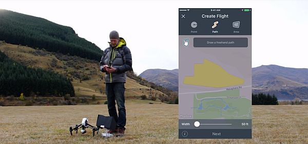
Airways is New Zealand’s air navigation service provider. They deliver air navigation and air traffic management consultancy and training services throughout New Zealand and in over 65 countries. Airways has now partnered with AirMap to conduct a three-month trial of New Zealand’s first UAV traffic management (UTM) platform. The trial is taking place in the Canterbury and Queenstown regions. Drone users can use AirMap’s free iOS and Android apps to obtain approvals, file flight plans, and access real-time information about other aircraft in the area.

Airways NZ AirMap trial

NTSB Aviation Incident Final Report on collision between Blackhawk helicopter and DJI Phantom

On September 21, 2017, a Sikorsky UH-60M Black Hawk helicopter operated by the U.S. Army collided with a privately owned and operated DJI Phantom 4 at about 300 feet MSL. The helicopter received minor damage while the Phantom was destroyed. The NTSB determined the probable cause(s) of this incident to be: “The failure of the sUAS pilot to see and avoid the helicopter due to his intentional flight beyond visual line of sight. Contributing to the incident was the sUAS pilot’s incomplete knowledge of the regulations and safe operating practices.”

More Than 600 Drones Were Crashed in the Name of UAV Safety Research

In order to better understand the injuries that could occur in a drone collision, Singapore’s Nanyang Technological University (NTU) Air Traffic Management Research Institute, crashed over 600 drones into dummy heads to gather as much data as possible. They found that a small 250 gram drone could kill a person.

NTU researchers test damage from drones on dummy heads

Turns out, you’re going to have to register your small drones with the U.S. government after all

On December 12, 2017, President Trump signed the National Defense Authorization Act for Fiscal Year 2018 into law. The FAA rules for drone registration and marking for small unmanned aircraft that were vacated by the court will be restored to effect.

Taking to the Air: Drones and Law Enforcement

Law enforcement agencies in Delaware are utilizing drones for a variety of purposes. Dover, Wilmington, and Ocean View agencies are using drones. So are the Delaware State Police, the Delaware Emergency Management Agency, and the state fire service. The drones are being used to monitor crowds during public events, survey homeless camps, monitor rallys and public exhibitions at schools, for aerial photography of crash scenes, to support court cases, and searching for suspects.

UAV207 Drone Racing with the Pro Aerial League

A new drone racing league takes shape, an unmanned aircraft vehicle traffic management system is planned for Kansas, Northrop Grumman’s MQ-25 drone tanker testbed was spotted, a Phantom landed on an aircraft carrier, DJI responds to issues over data transmission, and drones assist in a rescue mission.

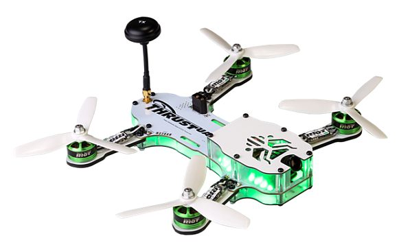
The RIOT 250R for the PAL drone racing league.

The RIOT 250R Pro racing drone. Courtesy Thrust-UAV.

UAV News

Professional drone racers start new league with six teams and big inaugural event in Everett arena

The Pro Aerial League (PAL) is a new drone racing organization that will feature indoor spectator events with six teams, each with six pilots. Pilots will race RIOT 250R Pro racing drones from Thrust-UAV through multiple types of challenges in order to determine the best team in terms of speed, skill, and strategy. The inaugural event is August 19, 2017, at the Xfinity Arena in Everett, Washington.

Riot 250R Pro by Thrust UAV Commercial

AirMap Takes Flight with Kansas

AirMap announced a partnership with the Kansas Department of Transportation (KDOT) to deploy the AirMap platform across the state. Their goal is “to open more airspace for drone operations, support Kansas’ growing community of drone operators, and ensure that the skies are safer for all.” The AirMap platform will be available to Kansas airports, state colleges and universities, and government agencies.

AirMap is one of the 12 companies assembled by the FAA for LAANC, the Low Altitude Authorization and Notification Capability, providing automated notification for flight in U.S. controlled airspace. A list of the initial 50 airports is available in Coming This Fall: Automated Airspace Authorization at U.S. Airports.

Northrop Grumman MQ-25 Drone Tanker Testbed Emerges At Plant 42 In California

Development contracts were previously awarded to Boeing, Lockheed Martin, General Atomics, and Northrop Grumman for the U.S. Navy’s MQ-25 Stingray drone. The MQ-25 Stingray is a carrier-launched tanker designed to extend the combat range of carrier aircraft. Aviation Week is now showing a low-quality photograph of what it says is Northrop Grumman’s modified X-47B flying test bed as part of its MQ-25 bid.

A drone landed on Britain’s biggest warship and nobody cared

A “Black Isle Images” photographer landed a DJI Phantom on the HMS Queen Elizabeth aircraft carrier. The landing was unintentional and the Phantom landed itself after sensing high winds. The photographer presented himself to the armed guards, but “no one seemed too concerned.” He also gave the authorities his phone number, but nobody called.

DJI Develops Option For Pilots To Fly Without Internet Data Transfer

DJI announced on August 14, 2017, that it is “developing a new local data mode that stops internet traffic to and from its flight control apps, in order to provide enhanced data privacy assurances for sensitive government and enterprise customers.” In local data mode, DJI apps will stop sending or receiving any data over the internet. That includes relevant local maps and geofencing data, the latest software updates, correct radio frequency and power requirements, and newly-issued flight restrictions.

First drone-assisted rescue in Southside a high-flying success

A logger on the Dan River in Virginia was pinned down by a tree. As the Danville Life Saving Crew traveled to the location, they created a plan that included using their drones. Just last month, they had received training to become certified drone operators, and on arrival at the scene, the drones were deployed to assist in making the operation safer. Danville Life Saving Crew assistant director Bryan Fox said, “We were able to navigate the boats around some circumstances in the water, some debris, rock formations, that [the rescuers] didn’t see from the boat as they were trying to navigate.”

UAV Video of the Week

On Sunday, July 2, 2017, a drone was spotted on the approach path to Gatwick Airport. This is the disruption it caused.

Gatwick drone incident – 2 July


UAV141 A New Drone Alliance

The Drone Manufacturers AllianceThe Drone Manufacturers Alliance is formed, a Digital Notice and Awareness System for airports starts, the Micro UAS Aviation Rulemaking Committee report is published, a satellite navigation system competition begins, and a new facial-recognition drone is available.

News

Drone coalition splits as DJI, GoPro faction quits

The Small UAV Coalition was formed to advocate “for law and policy changes to permit the operation of small unmanned aerial vehicles (UAVs) beyond the line-of-sight, with varying degrees of autonomy, for commercial, consumer, recreational and philanthropic purposes.”

Now DJI, GoPro, 3DR, and Parrot have left the Coalition to form The Drone Manufacturers Alliance to focus on small drone and consumer issues. The Alliance hasn’t yet developed official policy statements, but they do say they the Alliance “… will serve as the voice for drone manufacturers and our customers across civilian, governmental, recreational, commercial, nonprofit and public safety applications. We will advocate for policies that promote innovation and safety, and create a practical and responsible regulatory framework.”

Furthermore, “The Drone Manufacturers Alliance believes a carefully balanced regulatory framework requires input from all stakeholders and must recognize the value and necessity of continued technological innovation. By highlighting innovation and emphasizing education, we intend to work with policymakers to ensure drones continue to be safely integrated into the national airspace.”

AirMap and AAAE Launch UAS Notice System

AirMap and the American Association of Airport Executives (AAAE) have released the Digital Notice and Awareness System (D-NAS), designed to allow airport operators to be aware of drone flights in the area. D-NAS lets UAS operators transmit encrypted digital flight notices through a mobile device app to the airport’s operations center. The “flight plan” shows up on an airport computer with the planned location of the flight, radius, height, and duration.

The AP has learned a government-sponsored panel is backing standards that could allow commercial drones

The Micro Unmanned Aircraft Systems (UAS) Aviation Rulemaking Committee (the “ARC”) has delivered its report on proposed rules for flying over populated areas. The stated objective of the ARC was “to consider recommendations for a performance-based standard that would allow for micro UAS to be operated over people who are not directly participating in the operation of the UAS or under a covered structure,” which would ultimately contribute to an enforceable rule imposed by the FAA.

The Committee report Micro Unmanned Aircraft Systems Aviation Rulemaking Committee (ARC):  ARC Recommendations Final Report, [PDF] proposes to divide small UAS into four categories:

Under Category 1, a small UAS may operate over people if the weight (including accessories/payload, e.g., cameras) is 250 grams or less. The ARC believes that the level of risk of injury posed by this category of UAS is so low that no performance standards and no operational restrictions beyond those imposed by the proposed part 107 are necessary.

Under Categories 2, 3, and 4, a small UAS may operate over people if it does not exceed the impact energy threshold specified for each category, as certified by the manufacturer using industry consensus test methods, and if its operator complies with operational restrictions specified for each category. Because the level of risk increases between Categories 2, 3, and 4, the performance-based standards and operational restrictions are scaled-up in each category to mitigate the increased risks.

Category 2 applies to the larger multirotor UAS that are common for recreational and commercial drones. The UAS may operate over people if the manufacturer certifies to the FAA that the UAS does not, in the most probable failure modes, exceed the typical or likely impact energy threshold, and if it complies with industry consensus performance standards. The operator must also comply with the operator instruction manual, must maintain minimum set-off distances of 20 feet above people’s heads, or 10 feet laterally away from people, and may not operate so close to people as to create an undue hazard to those people.

Category 3 applies to UAS in commercial applications where the small number of people over which it might fly are all part of the commercial activity. The operation must be conducted over a closed or restricted-access work site with the permission of the site’s owner or operator. Overflight of people is limited to those who are transient or incidental to the operation.

Category 4 applies to small UAS that may operate over people, including flights over crowds or dense concentrations of people not included in Category 3. The manufacturer of the UAS must certify that the UAS does not, in the most probable failure modes, exceed the typical or likely impact energy threshold, and the UAS must comply with industry consensus performance standards. Significantly, the operation must be conducted in compliance with a documented, risk mitigation plan, which was developed and adopted in accordance with industry consensus standards for conducting risk mitigation.

For commercial operations, the Air Line Pilots Association and helicopter and crop dusting industry representatives wanted an aviation knowledge test administered by the FAA and a background check from the TSA. However, most Committee members wanted only an online knowledge test.

European Satellite Navigation Competition – Awarding Galileo Enabled Applications

The European Satellite Navigation Competition (ESNC) is said to be the largest international competition for the commercial use of satellite navigation. Thorsten Rudolph, the CEO of Anwendungszentrum GmbH Oberpfaffenhofen and initiator of the competition said, “We believe civilian drones have enormous potential in connection with the ESNC. We want to focus even more on the topic this year to promote the foundation of more visionary companies in the surrounding future market.”

The submission phase for services, products, and business innovations runs from 1 April to 30 June 2016. Visit the European Satellite Navigation Competition website for more information.

Facial recognition drone gives your selfie stick wings

People are obsessed with selfies these days. “Dronies” are the next technological step, and now we have the $349 ROAM-e drone from IoT Group that uses facial recognition technology to take self-portraits. The ROAM-e will follow you in the air for up to 20 minutes, fly within 25m of you, and always stay in constant view.

Images of the Week

Aerial views of fairy tale castles from around the world

Images of restored ancient fortresses as captured by drones.

Mentioned

CASA develops new regulations for drone operation

What the SUAS Industry Really Thinks about U.S. Drone Regulations

A five-minute survey for drone pilots.